Details of Tuscaloosa Tornado Track Seen from Space
Get the world’s most fascinating discoveries delivered straight to your inbox.
You are now subscribed
Your newsletter sign-up was successful
Want to add more newsletters?
Delivered Daily
Daily Newsletter
Sign up for the latest discoveries, groundbreaking research and fascinating breakthroughs that impact you and the wider world direct to your inbox.
Once a week
Life's Little Mysteries
Feed your curiosity with an exclusive mystery every week, solved with science and delivered direct to your inbox before it's seen anywhere else.
Once a week
How It Works
Sign up to our free science & technology newsletter for your weekly fix of fascinating articles, quick quizzes, amazing images, and more
Delivered daily
Space.com Newsletter
Breaking space news, the latest updates on rocket launches, skywatching events and more!
Once a month
Watch This Space
Sign up to our monthly entertainment newsletter to keep up with all our coverage of the latest sci-fi and space movies, tv shows, games and books.
Once a week
Night Sky This Week
Discover this week's must-see night sky events, moon phases, and stunning astrophotos. Sign up for our skywatching newsletter and explore the universe with us!
Join the club
Get full access to premium articles, exclusive features and a growing list of member rewards.
On April 27, 2011, a devastating tornado tore through Tuscaloosa, Alabama. The storm packed winds of 190 miles (310 kilometers per hour) and left a path of debris running southwest to northeast, according to a NASA statement. 
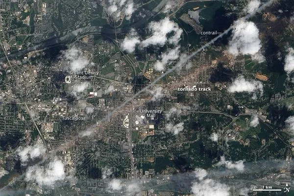
On May 2, 2011, the Advanced Land Imager (ALI) on NASA's Earth Observing-1 (EO-1) satellite captured this natural-color image of the tornado track through Tuscaloosa.
The tan-toned, debris-filled path passes through the center of town, affecting both commercial and residential properties. The track passes south of Bryant Denny Stadium and just north of University Mall. The mayor of Tuscaloosa estimated the cost of clearing the debris to be between $70 and $100 million.
Running roughly parallel to the tornado track is a contrail from a plane.
The National Oceanic and Atmospheric Administration (NOAA) reported that the tornado was spawned by a supercell thunderstorm that lasted more than seven hours. The supercell started in Newton County, Mississippi, at 2:54 p.m. Central Daylight Time (CDT), and finally ended in Macon County, North Carolina, at 10:18 p.m. CDT. The trail of damage stretched 80.3 miles (129.2 kilometers) long and as much as 1.5 miles (2.4 kilometers) wide.
Between 7:00 a.m. CDT on April 25 and 7:00 a.m. on April 28, a total of 362 tornadoes struck the southeastern and central United States, according to NOAA. The tornado that passed through Tuscaloosa caused more than 1,000 injuries and at least 65 deaths across several town and cities, the highest number of fatalities from a single tornado in the United States since May 25, 1955.
Why Were the Southern Tornadoes so Deadly?
Incredible Facts: Record-Breaking 2011 Tornado Season
Get the world’s most fascinating discoveries delivered straight to your inbox.

