Tropical Cyclone Zaka developed over the Pacific Ocean over the weekend and has become a tropical storm.
The storm, the latest to develop after Cyclone Yasi pummeled Australia last week, is nearing Raoul Island (also called Sunday Island), the largest and northernmost of the main Kermadec Islands. It's located about 680 miles (1,100 kilometers) north-northeast of New Zealand's North Island.
Zaka is expected to track near northeastern New Zealand, according to a NASA statement.
Latest Videos From
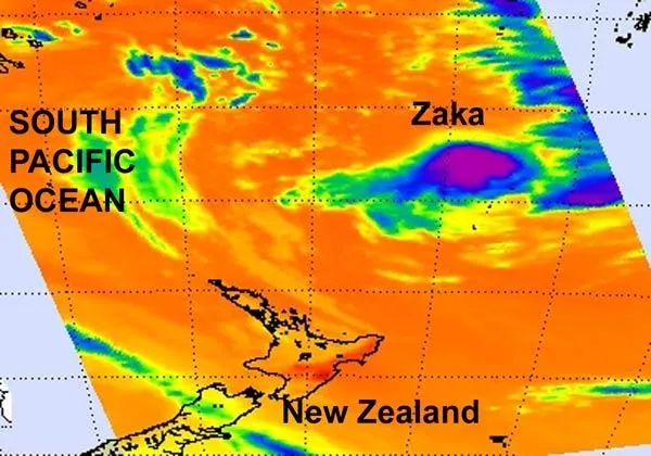
The above images of the storm was taken by NASA's Aqua satellite and shows the temperatures of the cloud tops. The data showed that a large area of strong thunderstorms with heavy rainfall surrounded the center of the storm.
Satellite imagery also shows that Zaka has a well-defined center of circulation, and convection (rapidly rising air that forms the thunderstorms that make up a tropical cyclone) and thunderstorms are wrapping around the storm's eastern side.
The reason for more thunderstorms and convection on the east side of the storm is an upper-level low pressure area sitting to the northwest of the storm. That upper-level low is suppressing convection on the western side of Zaka.
New Zealand's Metservice expects Tropical Storm Zaka to bring thunderstorms, gusty winds, rough surf and heavy rainfall to Raoul Island as it passes between 90 and 120 miles (150 to 200 km) west of the island this evening (New Zealand local time).
Zaka had maximum sustained winds near 40 mph (64 kph) at 0900 UTC (4 a.m. EST) today. It was still 550 miles (885 km) northeast of Auckland, New Zealand, and was moving south-southwest near 25 mph (40 kph) and kicking up waves 14 feet (4.2 meters) high.
Because Zaka is moving into an area with increased wind shear (winds that can weaken and tear a storm apart) it is expected to weaken as it passes northeast of New Zealand's North Island tomorrow.