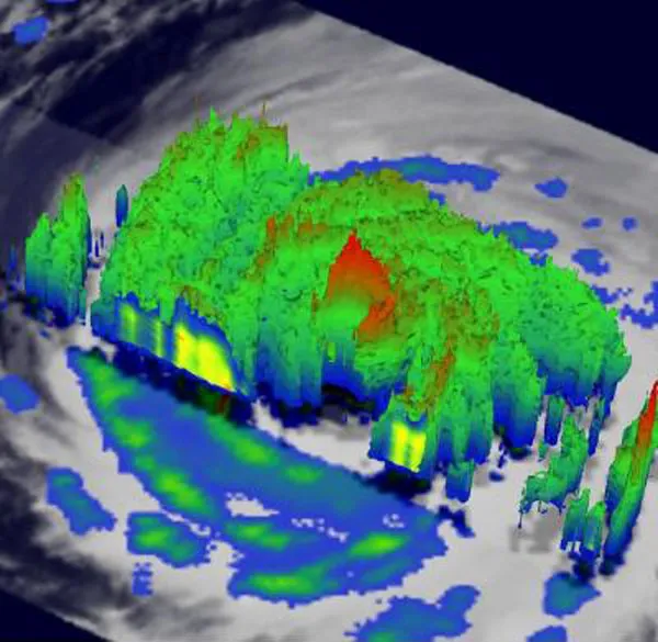
A NASA satellite is giving scientists a 3-D view of monstrous Hurricane Igor as it churns across the Atlantic.
The Tropical Rainfall Measuring Mission (TRMM) satellite is providing some of the first spaceborne rain radar and microwave radiometric a tool that detects electromagnetic energy- data to measure the distribution of rainfall over the tropics, and has lent its instruments to probing Igor's swirling clouds and lashing rains.
The TRMM satellite, operated by NASA and the Japanese Space Agency covers the tropics daily, providing two-dimensional views of rainfall rates within a tropical cyclone. TRMM data is also used to give forecasters a 3-D look at a storm's cloud heights and rainfall, which can be extremely helpful to hurricane forecasters who use the information in making their daily predictions on how hurricanes will develop.
Latest Videos FromLive Science
Igor has been creating dangerous surf in the eastern Atlantic Ocean that could affect the U.S. East Coast in the coming days. Igor is an extremely dangerous Category 4 hurricane that is expected to remain a large and powerful storm over the next several days and is on track for a bulls-eye hit of Bermuda near the end of the weekend, according to NASA.
The 3-D images of Igor show towering clouds, or "hot towers" over 9 miles (15 kilometers) high. Those hot towers are an indication of a strong storm. They also showed that Igor's eye (the clear center of the storm) was still very distinct, but the southwestern portion of the eye wall had eroded. In addition, the image shows a large area of heavy rainfall, falling at about 2 inches (5 centimeters) per hour.