


Southwest Storm to Deliver Denver's Biggest Snow
This article was provided by AccuWeather.com.
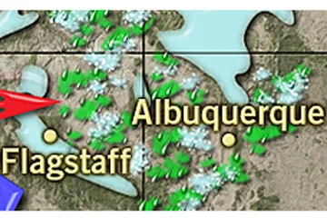
More snow is headed for the Four Corners states over the weekend, bringing roadway travel disruptions to Denver, Flagstaff and the mountains in the region.
As storms move through California, gusty winds can kick up dust over the deserts from California to West Texas.

Most gusts will range from 40 to 50 mph in Arizona to 50 to 60 mph in New Mexico and parts of Texas. Winds will be higher over the ridges and through the passes.
With cold air moving in high overhead and the lower atmosphere being relatively warm, thunderstorms with hail are a possibility in the region.

"A general half a foot to a foot of snow is in store for the mountains of Arizona, including the Flagstaff area, Friday into Friday night," Clark said.
Motorists should expect slow and slippery travel over the high country along I-40.
Get the world’s most fascinating discoveries delivered straight to your inbox.

Initially, rain will move into Salt Lake City late Friday, but snow can mix in at night over the Great Basin with accumulations trending upward over the Benches into the southern part of the Wasatch Mountains, where from 1 to 2 feet of snow can fall Friday night into Saturday.
Farther east over the Rockies from Colorado to northern New Mexico, this will also be a sizable snowstorm during the first part of the weekend.

This setup could bring a major snowstorm to Denver, with 6 to 10 inches of snow expected, late Friday night into Saturday night. This storm could be the biggest of the season for Denver.
March typically brings the biggest snowstorms of the year to the Mile High City, and this one could track just right to do the job. Significant snow will also fall on Colorado Springs and Pueblo.
It could prove to be disruptive for travelers in the area including those partaking in spring break activities in a warmer climate or heading to the slopes for a week of skiing. Highways I-25, I-70 and I-80 will be impacted by heavy snow in the region.
As the storm emerges from the Rockies and pushes onto the Great Plains later in the weekend, the risk of severe weather will increase from portions of Kansas and Missouri to the Gulf Coast.

The storm will also bring a surge of warmth to the eastern half of the nation, as well as drenching rain to part of the upper Mississippi River Basin and needed moisture in the form of snow to part of the northern Plains.
While any moisture from snow or rain is welcomed for water resources, it will not be enough on its own to quell concerns for water usage later this summer.
This story was published at 9:00 a.m. MST Thursday, March 6, 2013. It was updated at 8:00 a.m. MST Friday, March 7, 2013.
AccuWeather.com. All rights reserved. More from AccuWeather.com.
With much of the country experiencing an unseasonably warm winter, fears of climate change come to mind. See how well you understand recent weather, climate and the difference between them.
Weather vs. Climate Change: Test Yourself
