It's quick and easy to access Live Science Plus, simply enter your email below. We'll send you a confirmation and sign you up for our daily newsletter, keeping you up to date with the latest science news.
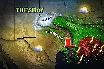
New Orleans, Mobile, Tallahassee, Hattiesburg, Pensacola and Dothan all find themselves in the area of greatest risk. This time, however, the thunderstorms will not pack as much of a punch.
The greatest threats will come from damaging gusts of wind and hail, rather than the strong to violent tornadoes that struck on Sunday.
Still, a brief spin-up of a weak tornado cannot be ruled out across the region.
The best timing for these storms looks to be late in the day and toward night, though a stray thunderstorms can occur at any time in the unseasonably warm and soupy air.
Sign up for the Live Science daily newsletter now
Get the world’s most fascinating discoveries delivered straight to your inbox.
If you'll be in New Orleans for Mardi Gras celebrations, it's a good idea to keep an eye on this situation. Plenty of delays are likely both on the roads and at the airports.
On top of the severe weather will also come the risk for significant flooding, especially from Hattiesburg to Montgomery and even Macon, a place that has seen exceptional drought for months on end.
If there is any shining light to be found on this situation, it is that the copious rainfall over the last several days will have substantial impact on improving the current drought situation across the Southeast.