
Space photos remind us that, around every corner of our vast universe, something spectacular awaits. From the newest James Webb Space Telescope images to historic photos of groundbreaking space missions, join us every Sunday as we explore the wonders of the universe, and humanity's place in it.
See more incredible space photos:
-
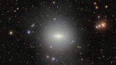 Scientists detect an enormous halo around the iconic Sombrero Galaxy — Space photo of the week
The 570-megapixel Dark Energy Camera in Chile has captured an extended halo and a dust-filled disk around the hat-shaped Sombrero Galaxy.
-
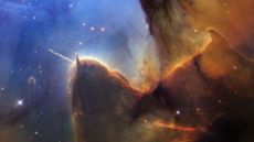 Hubble revisits stunning Trifid Nebula after 30 years, and spots a growing jet of energy — Space photo of the week
The Hubble Space Telescope revisits a star-forming region 5,000 light-years from Earth, which it first captured in 1997, revealing how the cosmic nursery has changed over human timescales.
-
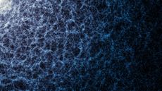 Largest-ever 3D map of the universe shows 47 million galaxies, from the Milky Way to 'cosmic noon' — Space photo of the week
The largest 3D map of the universe, created with data from the Dark Energy Spectroscopic Instrument, shows 47 million galaxies in stunning detail.
32 Comments -
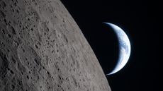 'Human minds shouldn't have to go through' this: Artemis II crew recalls unreal moment when Earth disappeared — Space photo of the week
A stunning Earthset image from Artemis II recalls Apollo 8's Earthrise, marking humanity's return to deep space and the start of a new era of exploration.
8 Comments -
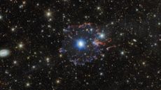
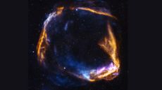 NASA telescope uncovers new mystery in supernova first spotted by Chinese astronomers 2,000 years ago — Space photo of the week
NASA's Imaging X-ray Polarimetry Explorer reveals the expansion and shock patterns within RCW 86, a supernova observed by early astronomers in A.D. 185.
2 Comments -
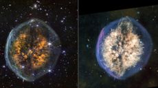
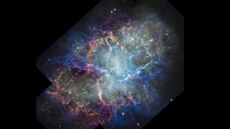 Hubble images taken 25 years apart show big changes in the iconic Crab Nebula — Space photo of the week
Astronomers reveal new insight into an iconic supernova remnant's evolution, structure and pulsar-driven growth over 25 years.
9 Comments -
 Rare star spotted in its original galaxy could answer a key question about the ingredients of life: Space photo of the week
The ancient and rare star PicII-503 is helping astronomers understand how carbon became so abundant in the universe.
-
 Hubble and Euclid capture the final act of a dying star — and it's glorious: Space photo of the week
Astronomers combined Hubble's small-scale details of stellar death with Euclid's wide view of cosmic environments to take a closer look at the iconic Cat's Eye Nebula.
-
 'Exposed Cranium' leaks its gory secrets in new James Webb telescope images: Space photo of the week
NASA's James Webb Space Telescope reveals new infrared images of the brain-shaped "Exposed Cranium" nebula, the final stages of a dying star.


