It's quick and easy to access Live Science Plus, simply enter your email below. We'll send you a confirmation and sign you up for our daily newsletter, keeping you up to date with the latest science news.
The most powerful East Coast earthquake in 100 years also sent tremors four times farther and over an area 20 times wider than similar quakes in other parts of the world, new research has found.
The Aug. 23, 2011, Virginia earthquake triggered small rockfalls 150 miles (245 kilometers) away from the epicenter, by far the greatest landslide distance recorded from any similar-magnitude quake worldwide, according to the research, which was presented on Nov. 6 at the annual meeting of the Geological Society of America (GSA) in Charlotte, N.C. For comparison, a similar event centered on an active fault at a Los Angeles beach would have only loosened rocks 36 miles (60 km) away at the Hollywood sign — not caused landslides at the border with Mexico.
"In the Eastern U.S., you might have smaller earthquakes, but they will be felt over a much larger area," said study co-author Randall Jibson, a geologist with the U.S. Geological Survey (USGS) in Denver. "They're felt about 20 times over the area that the same earthquake would be felt in the western U.S." [Infographic: Earthquake Shakes Northeastern US]
Jibson's analysis suggests major cities along the East Coast face a greater seismic hazard than previously thought.
"I think what we're hoping is that it's a wake-up call," Jibson told OurAmazingPlanet. "There are fewer earthquakes in the East than in the West, and they tend be a little smaller, but in a bad way, you get more bang for the buck."
The culprit behind the extensive shaking appears to be geologic structures within the Appalachian Mountains, whose gentle curves reflect the twisted remains of ancient continental collisions. The Appalachian bedrock seems to channel seismic energy parallel to the mountain's north-south orientation, according to several studies presented during the same GSA meeting session, while fractures, faults and other structures impede travel perpendicular to the range.
Sign up for the Live Science daily newsletter now
Get the world’s most fascinating discoveries delivered straight to your inbox.
"We've got three or four lines of evidence that seem to show seismic waves travel much more efficiently along than across it," Jibson said. "It's just easier to go along the structure than go across all these discontinuities."
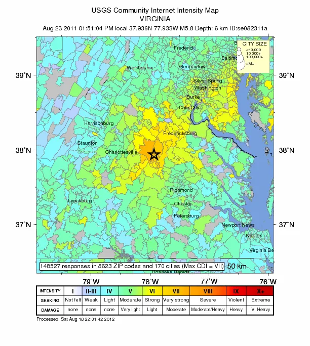
The same pattern appears on the USGS "Did You Feel It" plots from the Virginia quake, which map online reports from residents in the earthquake zone. The quake was felt by as many as 100 million people, from Florida to southeastern Canada, and caused $200 million in damage, the USGS said in a recent statement.
Eyes on the ground
Jibson and USGS colleague Edwin Harp analyzed landslides because the fallen rocks serve as crude seismic recording stations, he said. "They tell us how much shaking it takes to knock down the very weakest things," he said.
Map showing landslide limits from the Aug. 23, 2011, Virginia earthquake. The star indicates the epicenter; large crosses are landslide limits. The bold line shows a best-fit ellipse centered at the epicenter and passing through the observed limits (dashed where inferred beyond limits).
(Image credit: BSSA Vol. 102:6)
In an age of satellite mapping and airborne radar, the pairtracked down each tiny rock pile in a decidedly more low-tech manner: driving around in a rental car to find them. In the week following the earthquake, they drove outward from the epicenter along transects, looking for evidence of fresh landslides on steep slopes. They would stop frequently along road cuts to overturn rocks, looking for fresh grass underneath — a sign that the rock could have fallen during the quake.
"It was old-fashioned detective work," Jibson said. The slides caused no damage or injuries.
Landslides covered an area of about 12,900 square miles (33,400 square km) — about 20 times larger than expected. Previous studies predicted an area of about 580 square miles (1,500 square km) from a 5.8-magnitude earthquake.
"This particular observation is pretty significant in how we predict and therefore prepare for future earthquakes," Jibson said. "We have equations that predict how strongly the ground will shake for a given earthquake, and those assume the ground will shake evenly out in a given direction. The people who put those equations together might need to adjust the equations," he said.
The detailed report of the findings will appear in the December issue of the Bulletin of the Seismological Society of America.
Becky Oskin covers Earth science, climate change and space, as well as general science topics. Becky was a science reporter at Live Science and The Pasadena Star-News; she has freelanced for New Scientist and the American Institute of Physics. She earned a master's degree in geology from Caltech, a bachelor's degree from Washington State University, and a graduate certificate in science writing from the University of California, Santa Cruz.

 Live Science Plus