It's quick and easy to access Live Science Plus, simply enter your email below. We'll send you a confirmation and sign you up for our daily newsletter, keeping you up to date with the latest science news.
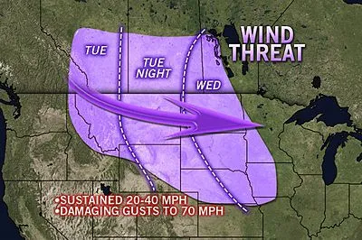
Residents of the northern Rockies and northern Plains should prepare for damaging winds spanning later Tuesday through Wednesday, as a powerful windstorm sweeps through the region.
Many places from Great Falls, Mont., to Kansas City, Mo., could be hit with wind gusts between 50 and 70 mph.
Other cities in the massive wind tunnel include Rapid City, S.D.; Bismarck, N.D.; Omaha, Neb.; Denver, Colo.; and Des Moines, Iowa. The core of the strongest winds will pass south of Minneapolis.
Gusts as high as 90 mph will hammer the ridges and mountain passes of the northern Rockies.
Approaching hurricane force, these winds will likely take down tree limbs and power lines, leading to power outages, property damage and travel concerns. There is a risk of vehicle rollovers in areas where there is a crosswind, especially in the I-25 corridor.
The same crosswinds can lead to flight delays at some airports.
Sign up for the Live Science daily newsletter now
Get the world’s most fascinating discoveries delivered straight to your inbox.
It is possible that winds produced by a non-tropical cyclone over the north-central U.S. may be stronger than the winds experienced in Bermuda with Hurricane Rafael passing east of the islands Tuesday night.
While the storm system and its winds will peak over the Plains, strong gusts will reach into the Ohio Valley and Great Lakes region by Thursday. Gusts to 50 mph are possible in St. Louis, Chicago, Indianapolis, Detroit, Louisville and Cincinnati.
A storm system that brought drenching rain to the Pacific Northwest Monday evening will rapidly strengthen as it pushes east of the Rockies, near the U.S./Canada border during the middle of the week.
Expert Senior Meteorologist Alex Sosnowski contributed to the content of this story.
The only sure thing about weather forecasts is that they’re wildly different all over the planet. Test your knowledge on the wild ranges in temperature, precipitation and more.

 Live Science Plus