It's quick and easy to access Live Science Plus, simply enter your email below. We'll send you a confirmation and sign you up for our daily newsletter, keeping you up to date with the latest science news.
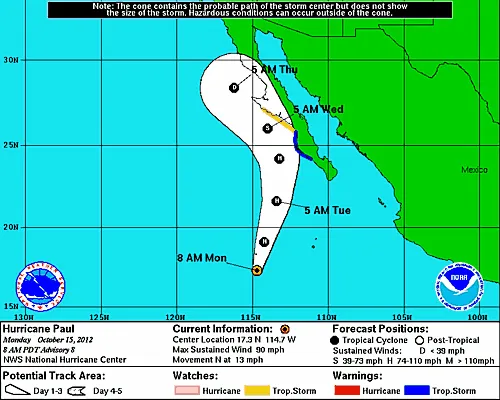
Hurricane Paul has formed out of a mass of moisture in the eastern Pacific and is set to bring significant impacts to Baja California.
Currently a hurricane, Paul is moving slowly towards to north-northwest across the western Pacific, however by the end of the day on Monday, the storms should take a significant turn to the north, and eventually northeast.
While most current model forecasts keep the center of the storm from making landfall, the storm will still manage to bring significant impacts as it grazes the coastline.
As the the storm moves north, significant rainfall will occur across the Baja Peninsula as early as Tuesday. Flash flooding will be a major concern to the area due to the amount of rainfall possible.
As the storm moves north it will initially begin to strengthen, as low wind shear and warm ocean temperatures help the system develop. Paul has a moderate chance of reaching hurricane strength over the next couple of days.
However farther north, shear will increase while ocean temperatures will rapidly decrease, creating an unfavorable situation for the system.
Sign up for the Live Science daily newsletter now
Get the world’s most fascinating discoveries delivered straight to your inbox.
As the storm grazes Baja California, it will begin to turn to the northwest and eventually dissipate over the cold waters of the region.
While bringing major impacts to the Baja Peninsula and northwestern Mexico, the moisture from Paul is not expected to bring major impacts to the southwestern U.S. There is however the chance that the system will bring some showers and thunderstorms to the deserts of southern Arizona and Southern California mid to lake week.
With much of the country experiencing an unseasonably warm winter, fears of climate change come to mind. See how well you understand recent weather, climate and the difference between them.