


Replacement Weather Satellite for GOES East
This article was provided by AccuWeather.com.
Like the National Football League referee situation, the National Oceanic and Atmospheric Administration (NOAA) is using a replacement satellite to cover the failure of GOES-13.
A major weather satellite operated by the U.S. government to monitor the east coast of the U.S. and the Atlantic Ocean has gone dark due to technical issues.
The failure of Satellite GOES-13 (GOES-East) satellite has left a gap for meteorologists trying to catch a view of the eastern Atlantic and has satellite coverage of the Atlantic spread a bit thin.
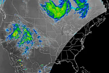
GOES-14 was activated and repositioned on Monday to fill part of the void left to satellite imagery in eastern North America and the Atlantic. However, images on the eastern edge of view, over the eastern Atlantic are distorted.
While other satellites of the eastern Atlantic are available, such as the European operated, METEOSAT, it makes the tracking of systems within the entire basin as a whole more difficult.
The U.S also has polar orbiting satellites. However, the images are rather narrow and not continuous, like the GOES, geostationary satellites.
Get the world’s most fascinating discoveries delivered straight to your inbox.
The National Oceanic and Atmospheric Administration (NOAA) confirmed Monday that GOES-13 has been placed in stand-by mode, following increased vibrations, or "noise," observed in imagery over the past couple of days.
Launched in 2006, GOES-13 went operational in 2010 and was expected to remain in service for several more years.
Stand-by mode means the satellite has basically been taken offline until problems are resolved.
The vibrations were severe enough that data collection and imagery was returning to earth significantly degraded over the past couple of days.
NOAA engineers are currently working on a solution to correct the problem with GOES-13 from the ground and have no timetable for return of data collection.
Earlier this year, in March, GOES-15 (GOES-West) was out of action for several days and it was GOES-13 that had to be repositioned to fill part of the gap. The result was distorted images on part of the Pacific Basin for a time.
Launch of the first of a new generation of weather satellites, known as the GOES-R series is not scheduled to begin until 2015.
Satellite images and loops are is available for free at AccuWeather.com.
Expert Senior Meteorologist Alex Sosnowski contributed to the content of this story.
© AccuWeather.com. All rights reserved. More from AccuWeather.com.