It's quick and easy to access Live Science Plus, simply enter your email below. We'll send you a confirmation and sign you up for our daily newsletter, keeping you up to date with the latest science news.
Tropical Depression 14 formed earlier today (Sept. 11) out over the Atlantic Ocean, and NASA has one of its unmanned Global Hawk drones in the air to investigate the burgeoning storm.
The Global Hawk is part of NASA's Hurricane and Severe Storm Sentinel (HS3) airborne mission, which began its latest field campaign on Sept. 7, just in time for the peak of the Atlantic hurricane season.
NASA reported that the Global Hawk left its Wallops Flight Facility on Wallops Island, Va., this morning for a planned 26-hour flight to the tropical depression to gather data that will be of use to forecasters and scientists seeking to better understand how tropical cyclones form and behave. (Tropical cyclone is the generic terms for typhoons, hurricanes and tropical storms.)
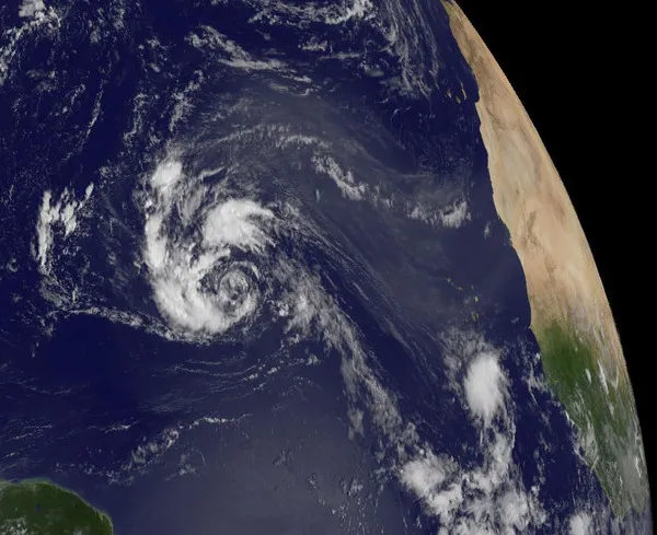
On Sept. 10, the TRMM satellite showed System 91L was getting organized and that convective storms were dropping heavy rain to the northwest and northeast of the center of the circulation. Those thunderstorms northeast of the center were reaching heights of about 13 kilometers (about 8 miles).
(Image credit: NASA/SSAI, Hal Pierce)
Tropical Depression 14 currently has maximum sustained winds of 35 mph (55 kph) and is located 1,210 miles (1,950 kilometers) east of the Lesser Antilles, according to the latest public advisory on the storm from National Hurricane Center (NHC).
NHC forecasters expect the storm to strengthen and become a tropical storm later today or tonight. If it does become a tropical storm, it will be called Nadine and will be the fourteenth named storm of the 2012 hurricane season.
NASA also has another eye in the sky watching the storm: On Sept. 10, the Tropical Rainfall Measuring Mission (TRMM) satellite passed over the system and data from TRMM's Microwave Imager (TMI) and Precipitation Radar (PR) were used to create a rainfall analysis, according to a NASA release. The data showed that the storm was organizing and that convective storms, a key component of tropical cyclones, were dumping rain in the northeast and northwest quadrants of the storm.
Get the world’s most fascinating discoveries delivered straight to your inbox.
Another storm, Tropical Storm Michael, is still swirling over the northern Atlantic Ocean. It was previously a hurricane, one of seven to form so far this season. The National Oceanic and Atmospheric Administration forecast for the 2012 season calls for between 12 and 17 named storms, of which forecasters expect five to eight will become hurricanes.
This story was provided by OurAmazingPlanet, a sister site to Live Science.
For the science geek in everyone, Live Science offers a fascinating window into the natural and technological world, delivering comprehensive and compelling news and analysis on everything from dinosaur discoveries, archaeological finds and amazing animals to health, innovation and wearable technology. We aim to empower and inspire our readers with the tools needed to understand the world and appreciate its everyday awe.