It's quick and easy to access Live Science Plus, simply enter your email below. We'll send you a confirmation and sign you up for our daily newsletter, keeping you up to date with the latest science news.
A strong disturbance that moved off the coast of Africa over the Atlantic Ocean earlier this week is being watched for development next week.
According to Tropical Weather Expert Dan Kottlowski, "The system is a bit farther south and is the strongest of the disturbances thus far this season originating from Africa."
Since the system is farther south it is a bit more removed from dry air and dust that has inhibited development of the systems moving westward off of Africa thus far. The dust is still there. However, the amount of dust has backed off a bit in recent days.
"We have reason to believe the feature will start to drift north of west at some point this weekend. Depending on how much of a northward turn occurs later on in the western Atlantic, the system has a chance at developing," Kottlowski said.
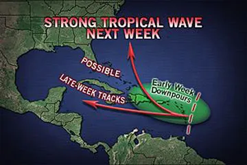
The feature will either continue moving westward or could curve to the northwest and north with time next week, if it senses the outer edge of high pressure over the central Atlantic.
"Physics of the feature curving around the high could spark development," Kottlowski added.
Sign up for the Live Science daily newsletter now
Get the world’s most fascinating discoveries delivered straight to your inbox.
The system already has a notable circulation and a weak surface low pressure area.
At the very least there is the potential for a period of showers and thunderstorms in part of the Caribbean islands next week.
Early in the week, the system will be near the Lesser Antilles, but will then push toward the Greater Antilles and/or the Bahamas later next week.
"Typically, during seasons where dust has become an issue, it tends to remain an issue and limit development of systems over much of the season." Kottlowski added.
The weather is getting stranger, right? Well, for the most part no, scientists say, but humans often think so when a strange event does occur. So here’s your chance to prove how much you known about weather oddities.

 Live Science Plus