The La Niña that helped fuel some of the wild weather over the past year may die down again this spring, after a brief fall comeback, government climatologists announced today (Feb. 9).
For those with an eye on the weather, the La Niña climate pattern has become a household name. The name is Spanish for "little girl," and it's a cyclical system of trade winds that cools the waters of the equatorial Pacific (El Niño is La Niña's warm-water counterpart.). La Niña can muck with global weather patterns, recurring every few years and lingering for as long as two years at a time.
The strong 2010-11 La Niña contributed to record winter snowfall, spring flooding and drought in different regions of the United States, as well as extreme weather events throughout the world, such as heavy rain in Australia and an extremely dry equatorial eastern Africa.
Latest Videos From
The recent La Niña is one of the strongest since climatologists began recording the phenomenon 50 years ago. The La Niña died over the summer, with neutral conditions developing and continuing until early fall. But in September, La Niña made a comeback in the tropical Pacific Ocean and gradually strengthened through winter.
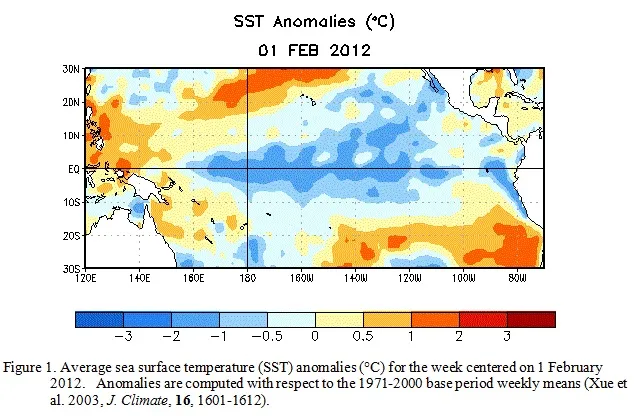
A mature La Niña continued during January 2012 with below-average sea-surface temperatures across the equatorial Pacific Ocean. Now, it's on its way out again.
"A majority of models predict La Niña to weaken through the rest of the Northern Hemisphere winter 2011-12, and then to dissipate during the spring 2012," according to the outlook released today by forecasters at the U.S. National Oceanic and Atmospheric Administration's (NOAA) Climate Prediction Center.
According to climate and weather experts, 2011's record-breaking number of billion-dollar weather disasters was caused by a combination of factors, including La Niña, local atmospheric patterns and, potentially, climate change — though the importance of climate in any individual weather scenario is still nearly impossible to put an exact number on. One NASA scientist even called "La Nada" — the disappearance of La Niña — the real wild weather culprit, particularly for spring's deadly tornado season, as it affected the position of the jet stream over the United States.
Follow OurAmazingPlanet for the latest in Earth science and exploration news on Twitter @OAPlanet and on Facebook.