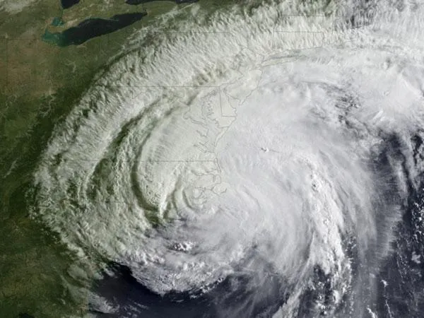
The extensive hurricane watches and warnings issued for Hurricane Irene were the most extensive in a decade, stretching from South Carolina to Maine. But Irene is not the first storm to spawn such extensive warnings. During Hurricane Floyd in 1999, "watches and warnings were issued for that hurricane from South Florida to Massachusetts," said Dennis Feltgen, public affairs officer for the National Hurricane Center.
Though Irene won't top that breadth of warnings, it may tie with Gloria.
"Hurricane Gloria in 1985 also had extensive warnings from the Carolinas to Maine," Feltgen told LiveScience. "Too close to call between Gloria and Irene — we'd have to do some serious research, which we can't do right now for obvious reasons — but Floyd is number 1."
Latest Videos From
Both Floyd and Gloria did wreak some havoc, with Gloria reaching Category 4 intensity on the Saffir-Simpson Hurricane Scale as it moved to the east of the Bahamas, before moving northward over the Outer Banks of North Carolina and making a second landfall on western Long Island. The storm resulted in eight deaths and $400 million in damage. [Are Category 6 Hurricanes Coming Soon?]
Floyd neared Category 5 status as it pounded the Bahamas in 1999, before threatening Florida and striking the coast of North Carolina. Ultimately, Floyd dumped as much as 2 feet (0.6 meters) of rain in some places along the east coast, resulting in 56 fatalities and $6 billion in property losses, according to the National Oceanic and Atmospheric Administration (NOAA).
A hurricane watch means sustained winds of 74 mph (119 kph) or higher (considered hurricane conditions) are possible in an area within the following 48 hours, according to NOAA. A hurricane warning means hurricane conditions are expected within that specified area, and these are issued 36 hours in advance of the anticipated onset of such winds.
Follow Live Science for the latest in science news and discoveries on Twitter @livescience and on Facebook.