
 Live Science Plus


Did a 'Gustnado' Topple Stage in Indiana?
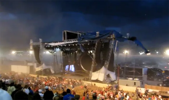
Investigators are searching for clues about the Aug. 13 stage collapse at the Indiana State Fair in Indianapolis that killed five people.
Some meteorologists think a kind of wind storm called a 'gustnado' could be to blame.
Cousins to tornadoes, gustnadoes are brief, low-to-the-ground swirling clouds. They are relatively weak compared to tornadoes, but they can still pack a punch and are capable of knocking over weak structures.

At the very least, the damage was caused by a strong gust front, or outflow boundary. This front is what separates thunderstorm-cooled air from the warmer air surrounding it. Gustnadoes are known to develop along gust fronts.
"The video shows a swirl of dust coming across the stage, and it's only when the swirl hits the stage that the stage actually collapses," according to meteorologists at AccuWeather.com.
[Click here to see the video on YouTube. Warning: The footage may be considered disturbing.]
Weather slang
Get the world’s most fascinating discoveries delivered straight to your inbox.
The gustnado designation hasn't been given to the Indiana storm by the National Weather Service.
"Normally we don't classify an event as a gustnado," said Dave Tucek, a meteorologist with the NWS in Indianapolis. According to the NWS storm report, the wind gusts were estimated at between 60 and 70 mph (97 and 113 kph).
Gustnado wind speeds can reach 80 mph (129 kph), according to the National Weather Service. Winds of that speed can cause damage similar to that of an EF-0 or EF-1 tornado, the lowest rankings on the tornado damage scale.
Tucek told OurAmazingPlanet that from the videos he has watched, he does not see evidence of a swirling motion in the dust and that "it's hard to say for sure," whether a gustnado formed.
Investigation continues
If a tornado had struck, storm survey teams for the NWS would be investigating to determine the strength. The Indianapolis NWS station has no plans to send a team to investigate the wind damage, Tucek said. The Indiana Occupational Safety and Health Administration and the state fire marshal's office are investigating what caused the collapse, reported the New York Times.
Telling the difference between a strong gustnado and a tornado can be tricky.
Gustnadoes may be accompanied by rain, just like tornadoes, but they are usually wispy or only visible as a debris cloud or dust whirl — a far cry from the dense and menacing funnel clouds of tornadoes.
Yet small tornadoes can seem wispy at first; the key is to look at the top of the suspected gustnado. Unlike tornadoes, gustnadoes are not connected to the storm clouds above, sticking closer to the ground.
True tornadoes spin off huge rotating storm clouds, called mesocyclones, which can tower tens of thousands of feet into the sky. Gustnadoes are more likely to be associated with a shelf cloud, a low, horizontal structure in the front of a thunderstorm.
- Weirdo Weather: 7 Rare Weather Events
- Infographic: Tornado! How, When & Where Twisters Form
- The Top 5 Deadliest Tornado Years in U.S. History
Email OurAmazingPlanet staff writer Brett Israel at bisrael@techmedianetwork.com. Follow him on Twitter @btisrael.