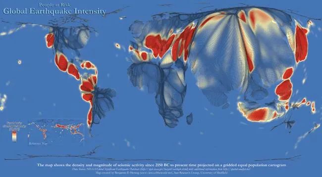
A new world map, created using 4,000 years of earthquake records, shows where people around the globe are most at risk from dangerous seismic activity.
The map provides a visualization of all major earthquakesfrom 2150 B.C. to the present day that meet at least one of several criteria, including causing approximately $1 million or more in damage, killing 10 or more people, generating a tsunami or having a magnitude of 7.5 or greater.
The map shows not only the areas that are at highest risk, but also demonstrates how this risk relates to global population distribution — in effect showing who is most at risk of seeing a major earthquake.
Latest Videos From
"Growing numbers of people live in highly vulnerable areas. The recent earthquakes in Japan and also in Christchurch are a tragic reminder of the fragile relationship between human livelihoods and natural hazards," said Benjamin Hennig, creator of the map and a postgraduate researcher in the Department of Geography at England's University of Sheffield.
In addition, Hennig has created a new, more detailed map of Japan, which shows that the majority of the island nation's urban population — 80 million people — are concentrated along the Pacific coast.
The map also includes Japan's topography and the surrounding ocean's geography and water depth, which played a crucial role in the development of the devastating tsunami that caused much of the destruction on the densely populated Pacific shore.
"The maps help us to get a better understanding of the relation between natural risks and global population patterns," Hennig said.

 Live Science Plus