 Live Science Plus


America's Endangered Rivers

Most of the United States' drinking water (65 percent) comes from rivers, which also nourish agriculture and ecosystems and provide recreational opportunities. But with so many demands on them, many of America's 250,000-plus rivers are threatened.
The nonprofit American Rivers highlights these dangers each year with its Most Endangered Rivers report. The report puts a spotlight on rivers that face important policy decisions that could make or break them in the next year. Threats range from excessive diversion of water to outdated dams to pollution.
Here are the 10 most endangered rivers the organization has identified in 2014 and what threats they face.
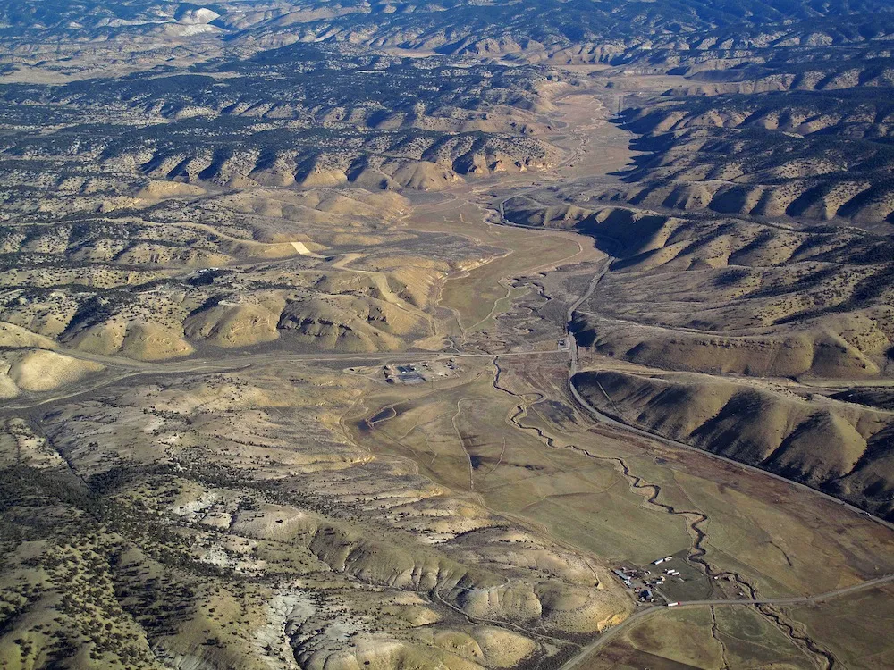
Article continues belowClearwater/Lochsa Rivers, Idaho

The Middle Fork Clearwater and a tributary, the Lochsa river, flow through the Clearwater National Forest in Idaho and provide sanctuary for endangered species such as the steelhead trout.
The Clearwater and Lochsa are threatened by manufacturing, particularly the transport of "megaloads" of refinery and mining equipment headed for the tar sands of northern Alberta in Canada, American Rivers reports. The megaloads dwarf most anything else on the highway: They can be 30 feet (9 m) wide, 30 feet (9 m) tall and 350 feet (107 m) long.
These huge, crawling loads threaten recreation on the river and are opposed by the Nez Perce Tribe, whose land the highway (U.S. 12) cuts through. Legal battles have determined that the Forest Service has the authority to ban megaload transport through the area, but it has not yet done so.
Haw River, North Carolina

The Haw River is in north-central North Carolina and flows into the Cape Fear River, which drains into the Atlantic near the city of Wilmington. In the 19th century, textile manufacturing polluted the river. Today, pollution remains the Haw's greatest threat.
Dangers now include raw sewage and pollution run-off. The Environmental Protection Agency (EPA) required the state to develop a plan to clean up the Haw, but the state government has passed laws stalling the plan.
White River, Washington

Mt. Rainer's glaciers feed the scenic White River of Washington state, which flows into the Puyallup River and Puget Sound. This river is a major salmon habitat, and public money funds salmon restoration projects to keep fish populations up.
But the Buckley Diversion Dam on the river kills many of these fish as they make their way upriver to spawn, American Rivers reports. The dam's primary purpose is as a gateway for fish, but the fish traps to transport the fish upriver are small and antiquated. American Rivers is calling for upgrades to fix the dams and save the fish that taxpayers shell out cash to restore.
White River, Colorado
Another White River makes the list of endangered waterways in the No. 7 spot. This White River is in northwestern Colorado, where it provides drinking water for 7,000 people in rural towns and supports a habitat full of fish and big game.
The White River is threatened by oil and gas development on public lands managed by the Bureau of Land Management (BLM). However, oil and gas interests paid for the environmental impact study and would allow more than 15,000 wells to be drilled on these lands. The impacts on wildlife, air and water quality could be wide-reaching.
South Fork of the Edisto River, South Carolina

The Edisto river is a slow-flowing blackwater river, so named because dark-colored tannins from vegetation dye the water nearly black. Endangered Atlantic sturgeon and shortnose sturgeon call the river home.
A single potato farm can draw as much as 35 percent of the river's flow during drought, a portion that can seriously impact fish and wildlife, American Rivers reports. The organization is calling for stronger permitting laws to prevent such large draw-downs without public notification. American Rivers is also calling for stricter limits on how much water can be removed in order to prevent conflicts between environmentalists, agribusiness and recreation.
San Francisquito Creek, California

Scenic San Francisquito Creek drains the eastern Santa Cruz mountains, trickling through the hamlets of Portola Valley and Woodside, Calif., before traveling through Palo Alto and into the south San Francisco Bay. Unlike most urban streams, the San Francisquito is not channelized, and is home to native species such as the tiger salamander.
San Francisquito Creek is marred by an outdated barrier, the Searsville Dam, which prevents steelhead trout from making it upstream. Stanford University owns the dam and its reservoir, which is 90 percent filled with sediment. A Stanford committee is currently studying alternatives to the dam and will present its findings at the end of 2014.
Gila River, New Mexico

New Mexico's Gila River starts in the Gila Wilderness and flows into the Colorado River. It provides water to some 5 million people and is a popular recreation river. American Rivers is raising concern about the Gila, however, because of a proposed diversion that would double current water withdrawals.
The state must decide whether to construct the diversion or to meet its water needs though water conservation alternatives by the end of the year.
Middle Mississippi, Missouri, Illinois and Kentucky

The Mississippi River is an extensively controlled river, but a gap in the levee at the New Madrid Floodway allows water to inundate a rich floodplain habitat, supporting migratory birds and rare fish.
A new levee proposed by the Army Corps of Engineers would change all that, cutting off water from 75,000 acres of wetlands. The Corps is finalizing the Environmental Impact Statement for the project this year. Depending on its conclusion, the Environmental Protection Agency (EPA) could veto the new construction under the Clean Water Act.
Upper Colorado River, Colorado

The Upper Colorado and its tributaries provide drinking water and recreation to residents of the Centennial State, as well as habitat to 14 native fish species. In 2013, the Colorado River made the No. 1 spot on American Rivers' "Most Endangered" list. This year, the Colorado Water Conservation Board is developing a statewide plan to handle water distribution from the Upper Colorado Basin.
The river is most threatened by water diversions to support Colorado's burgeoning population, 80 percent of whom live in the relatively arid Front Range. Diversions from the wetter western part of the state provide drinking water to Denver and other Front Range cities, but a long-term plan is needed to keep thirsty residents happy while protecting recreation, tourism and agriculture.
San Joaquin River, California

California's current drought is not doing its rivers any favors. But the San Joaquin, California's second-longest river, was in trouble even before the drought. More than 60 miles of the river run dry, according to the National Resources Defense Council, and increased pressure on the river's water could worsen the situation.
The California Water Resources Control Board is drafting a plan for the management of the San Joaquin, and American Rivers is calling for increased flows to restore habitat and downstream agriculture. The U.S. Senate also has the opportunity to reject the relaxation of environmental laws protecting the river flows, which could lead to more of the channel drying up.

