


Aftermath of a Storm: Images from Hurricane Katrina
Katrina Arrives

Hurricane Katrina moved ashore over southeast Louisiana and southern Mississippi early on August 29, 2005, as an extremely dangerous Category 4 storm. With winds of 135 miles per hour (217 kilometers per hour), a powerful storm surge, and heavy rains, Katrina pounded the U.S. Gulf Coast, triggering extensive life-threatening flooding.
This GOES satellite image shows the storm as it moved over southern Mississippi at 9:02 a.m. The eye of the storm was due east of New Orleans.
By mid-afternoon on August 29, Katrina had weakened into a Category 1 hurricane with winds of 95 mph (153 km/hr). A mere 24 hours earlier, Katrina had been one of the most powerful storms ever observed in the Atlantic Basin.
New Orleans Underwater

Water began flooding in to the lower reaches of New Orleans on the night Katrina hit, after the hurricane had battered the levees along the canals that run through the city from Lake Pontchartrain. The Advanced Land Imager on NASA's EO-1 satellite acquired this detailed image of the flooded city on Sept. 6, 2005.
A strip of the city along the banks of the Mississippi River remained dry. In this dry area, which included downtown New Orleans and the historic French Quarter, a white plume of smoke rose from a fire burning near the lower edge of the image.
Through the rest of the city, elevated sections of road and roof tops were the only things visible above the water. In the top center of the image, the grid of houses is interrupted where City Park was buried under a smooth blue-green pool of water. The bright white semi-circle seen on the south side of the park is the ring of seating in the open-air Tad Gormley Stadium. The source of the water, Lake Pontchartrain, can be seen along the top of the image, its waters still clouded by the silt stirred up by the storm.
New Orleans One Week Later

Although the breaches in the levees that allowed water to flow into New Orleans had been sealed by the time this satellite image was taken on Sept. 6, the city was still buried under a deep blue blanket of water and had been for more than a week.
A strip of the city along the banks of the Mississippi River remains dry. In this dry area, which includes downtown New Orleans and the historic French Quarter, a white plume of smoke rises from a fire burning near the lower edge of the image.
Through the rest of the city, elevated sections of road and roof tops are the only things visible above the water. In the top center of the image, the grid of houses is interrupted where City Park is buried under a smooth blue-green pool of water. The bright white semi-circle seen on the south side of the park is the ring of seating in the open-air Tad Gormley Stadium. The source of the water, Lake Pontchartrain, can be seen along the top of the image. The water remains clouded with silt stirred up from the lake's bottom when Hurricane Katrina passed overhead on Aug. 29.

Barrier Islands Before

A fringe of barrier islands lines the coast of Mississippi, protecting the mainland from the pounding waves of most storms that blow in from over the ocean. But the islands could not shelter the mainland from Hurricane Katrina's exceptionally powerful storm surge. The battering waves ate away at the islands, permanently altering their shape.
The image above, stitched together from two Advanced Spaceborne Thermal Emission and Reflection Radiometer (ASTER) images show the conditions of the barrier islands before Katrina barreled through. The left half, acquired on June 4, 2005, shows Cat Island, and the right half, from April 22, 2001, shows East and West Ship islands.
Barrier Islands After

This second image was taken on Sept. 8, 2005, nine days after Katrina hit. The most dramatic change can be seen in East Ship Island. Compared to April 2001, most of East Ship Island has disappeared beneath the ocean. The ghost shores of the island are faintly visible under the water as a lighter shade of blue. Some of the erosion may have occurred in other storms between 2001 and 2005, but Katrina is probably responsible for much of the damage.
West Ship Island, which hosts a civil war fort and a historic lighthouse, and Cat Island have also shrunk slightly. The southern tip of Cat Island is missing, and the pointed tips of Ship Island have been rounded out. The section of the northwestern shore that holds the lighthouse and fort seems to be unchanged.
Katrina isn't the first hurricane to inflict damage on these islands. East and West Ship islands had been a single island until Hurricane Camille cleaved it in two in 1969.
Biloxi
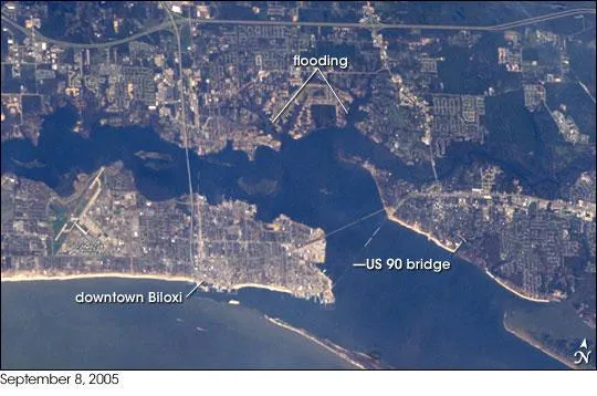
The port town of Biloxi, Mississippi, experienced significant damage when Hurricane Katrina came ashore.
This astronaut photograph illustrates damage and flooding in the Biloxi area caused by Hurricane Katrina. Damage to the 2.5-kilometer- (1.6- mile-) long US-90 bridge is evident the bridge is almost completely destroyed, with only two sections of roadbed still intact.
Flooded areas are indicated by dark greenish-brown coloration along river courses to the northeast and northwest of downtown. Most of the flood water remained within the rivers' floodplains.
Chandeleur Islands Before & After

The graceful curve of the Chandeleur Islands resembles a multi-boned spine connecting the Mississippi Gulf coast to the delta of the Mississippi River in Louisiana. Like all barrier islands, the Chandeleur Islands form a thin protective wall between the open sea and the mainland, in this case Louisiana's St. Bernard Parish. The islands absorb the strongest waves, sheltering the mainland during large storms. It is no surprise, then, that barrier islands along the U.S. Gulf Coast changed dramatically in the wake of Hurricane Katrina, and no change is as dramatic as that seen in the Chandeleur Islands.
Hurricane Katrina's strong winds, storm surge, and battering waves scoured the islands, leaving them reduced or gone altogether. These images of the islands were taken by the Landsat 5 satellite.
The top image, taken on Sept. 16, 2005, shows the Mississippi and Alabama coast line, including the line of islands that bore the brunt of Katrina's fury. The lower images show the northern section of the Chandeleur Islands at full resolution. In the 11 months that passed between Oct. 15, 2004, when the right image was taken, and Sept.16, 2005, when the left image was taken, the islands have wasted away.
Get the world’s most fascinating discoveries delivered straight to your inbox.
