Where Trade Routes Meet, a Mesa Rises
Get the world’s most fascinating discoveries delivered straight to your inbox.
You are now subscribed
Your newsletter sign-up was successful
Want to add more newsletters?
Delivered Daily
Daily Newsletter
Sign up for the latest discoveries, groundbreaking research and fascinating breakthroughs that impact you and the wider world direct to your inbox.
Once a week
Life's Little Mysteries
Feed your curiosity with an exclusive mystery every week, solved with science and delivered direct to your inbox before it's seen anywhere else.
Once a week
How It Works
Sign up to our free science & technology newsletter for your weekly fix of fascinating articles, quick quizzes, amazing images, and more
Delivered daily
Space.com Newsletter
Breaking space news, the latest updates on rocket launches, skywatching events and more!
Once a month
Watch This Space
Sign up to our monthly entertainment newsletter to keep up with all our coverage of the latest sci-fi and space movies, tv shows, games and books.
Once a week
Night Sky This Week
Discover this week's must-see night sky events, moon phases, and stunning astrophotos. Sign up for our skywatching newsletter and explore the universe with us!
Join the club
Get full access to premium articles, exclusive features and a growing list of member rewards.
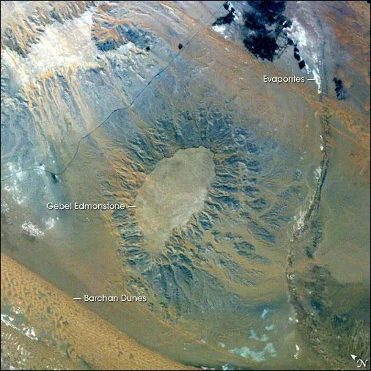
Gebel (or Mount) Edmonstone is a flat-topped mesa located near the Dahkla Oasis south of Cairo, Egypt. The Oasis is a historically important meeting place of several trade routes connecting different regions of Egypt and Sudan. Gebel Edmonstone is a remnant of an eroding scarp that extends for over 200 kilometers (125 miles) east-southeast to west-northwest (visible in the upper left corner of the image). The flat caprock of both the scarp and Mount Edmonstone is chalky limestone underlain by fossil-bearing shale and fine-grained sedimentary rocks.
Digital astronaut photographs can be processed in similar fashion to other multispectral remotely sensed data to maximize information content. This astronaut photograph has been stretched to enhance color variations in the various rock and soil units. The color variations reflect differences in composition (or weathering) of the various rock units. The limestone unit capping Gebel Edmonstone and the adjacent scarp ranges from white to gray in color, while the underlaying fine-grained sedimentary layers are blue-gray.
Hillslope pathways for sediment movement downslope are clearly visible as brown to tan streamers originating from Gebel Edmonstone. Barchan dune fields are also visible in this color-enhanced image, and are distinct due to their mineralogical composition. Evaporite deposits are bright white, while vegetated portions of the Oasismostly agricultural fieldsare dark blue-black. This additional information obtained from image enhancement can be used for geologic mapping and investigation of surficial processes operating in the region.
- New Mount Rainier Webcam Now Online
- Earthmovers: How Human Interference Can Cause Earthquakes
- The 10 Driest Places on Earth
Get the world’s most fascinating discoveries delivered straight to your inbox.

