
 Live Science Plus


7 Ways the Earth Changes in the Blink of an Eye
Intro
From islands popping out of the ocean during earthquakes to glaciers calving icebergs every hour, the Earth can undergo dramatic changes right before your eyes.
These seven rapid geological transformations have fascinated scientists and struck fear in the hearts of everyone else for ages.
A new coast

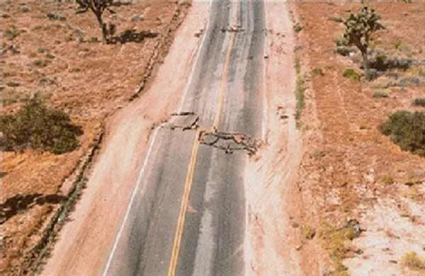
Earthquakes not only rattle the Earth, but they radically change the landscape. The Chilean earthquake that struck on Feb. 27 changed the country's landscape by raising the ground by more than 8 feet (2.5 meters) near the coast and sinking land farther inward, a recent study found.

The massive quake caused marine platforms to rise out of the ocean, thereby shifting the coastline in some places 1,640 feet (500 m) closer to the ocean. [See images of Chile's raised coast.]
Ice conveyor belt

Glaciers huge rivers of ice formed when snow and ice accumulate over hundreds and thousands of years act like a big conveyor belt that pushes ice into the sea. These icy rivers move slowly over time, some eventually dumping ice chunks into the sea, a process known as calving a leading source of additional water for the world's oceans.
Some kinds of glaciers, however, calve as often as once an hour. These kinds of glaciers are called "grounded," meaning they rest on the ocean floor; others float on top of the ocean waters as they run into the sea. Scientists recently observed Alaska's Columbia Glacier undergoing a transition from grounded to floating, which dramatically slowed its calving. [See scientists studying the glacier.]
Volcano collapse
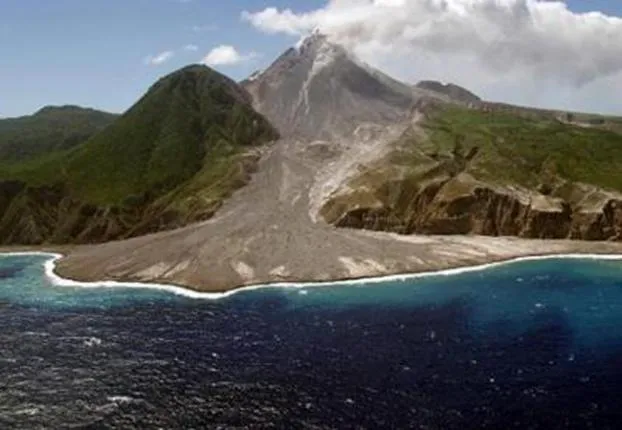
Massive volcanic eruptions unleash ash and pumice into the sky and can be heard thousands of miles away and even seen from space . But volcanoes can change the landscape in the blink of an eye in a way other than blowing off their tops by triggering huge landslides.
Get the world’s most fascinating discoveries delivered straight to your inbox.
Thousands of years ago, a large collapse of the edifice of the Soufriere Hills volcano on the island of Montserrat in the Lesser Antilles sent landslides into the ocean. Some of these landslides involved nearly 1.2 cubic miles (5 cubic kilometers) of material that travelled underwater for miles.
Volcanic dome collapses occur when dome-shaped lava mounds on top of a volcano break apart due to a gas pressure build-up. Soufriere Hills' eruptions have produced some of the largest volcanic dome collapses ever recorded.
Landslides

Landslides can wipe away villages in the blink of an eye even when volcanoes aren't involved. Heavy rains triggered landslides on the slopes of Mount Elgon in Uganda, on March 1, 2010.
Landslides are common in the region, but these recent landslides are much larger than previous ones. The landslides buried three villages, leaving 83 dead and more than 300 missing as of March 8, reported the United Nations Office for the Coordination of Humanitarian Affairs. The Ugandan government has also stated that deforestation may have played a role in the landslides.
Avalanches

When mountaintop glaciers collapse, they can trigger an avalanche of ice and debris down the mountain. Such was the case for Mt. Kazbeck in Southern Russia when the Kolka Glacier collapsed on Sept. 20, 2002.
In the above image, the dark grey streak shows the gorge that was overrun by ice, rock, water and other debris from the avalanche. The avalanche plowed down the Genaldon River Valley at speeds up to 112 mph (180 kph) and buried parts of a village with a layer of ice and rock 427 feet (130 meters) thick.
Avalanches, along with other deadly natural disasters such as heat waves and floods, could become more common in mountainous regions thanks to climate change, according to a recent study. In the Alps, where temperatures have increased twice as much as the global average temperature since the late 19th century and are predicted to rise by an average of 0.54 to 0.9 degrees Fahrenheit (0.3 to 0.5 Celsius) per decade in the next century, these threats are a real concern.
Rapid megafloods

Some of the most spectacular canyons on Earth (and Mars) were probably formed in the geologic blink of an eye, suggests a recent study that found clues to their formation deep in the heart of Texas.
As anyone living in Comal County, Texas can attest, they can form even faster. Lake Canyon Gorge, a 23-feet- deep (7 meters) canyon was carved in just three days by a flood in 2002. The flood scoured a swath of greenery in this Texas town, leaving sand-colored bedrock rubble in its wake.
A single catastrophic flood capable of cutting into bedrock is extremely rare, but the Comal flood gave scientists a front-row ticket to an event similar to those from the planet's distant past, geologists said.
Rapid megafloods may have formed other canyons in the distant past as glacial ice dams released trapped water. Large floods may be responsible for the formation of some Martian canyons as well, said geologists.
Meteor impact

Many meteors headed for Earth burn up in the planet's atmosphere. Those big enough to make it through leave quite an impression on the landscape.
The Earth's wind, water and vegetation will eventually erase most craters. With few exceptions, even the largest craters are eventually destroyed by the processes of plate tectonics.
The Barringer Crater, also known as Meteor Crater, is a 0.8-mile- (1,300-meter-) diameter, 570-foot- (174-m-) deep hole in the flat-lying desert sandstones that lies 18.6 miles (30 kilometers) west of Winslow, Ariz. [See other meteor craters across the Earth.]