
 Live Science Plus


Chile's Raised Coast
Caleta Yane

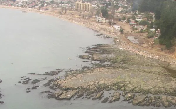
The Chilean earthquake that struck on Feb. 27 changed the country's landscape by raising the ground near the coast and sinking land farther inward, a new study finds. Here on the Arauco Peninsula, the uplift of a marine terrace displaced the coastline about 980 feet (300 meters) seaward.
New coast

Uplift of the ground is seen at the beach of Lebu. Uplift in this zone was about 71 inches (180 centimeters), which produced the uplift of a great marine platform.
Punta Lavapié

An uplifted marine platform was found at Punta Lavapié (the northernmost tip of the Arauco Peninsula). Here, the coastline before the earthquake was just at the foot of the cliff.

This photograph shows several species of dead algae and mollusks that lived in the coastal waters.
The white coating on the rocks is from the dead algae. Researchers used the white fringe to measure how far the land had risen after the earthquake. These normally pink algae, common in Chilean coastal waters, are bleached and dried out by sunshine. The algae died and turned white when the land was pushed above the water's surface.
Santa Maria Island

At the southern end of Santa Maria Island, several marine platforms uplifted more than 5 feet (1.5 m), leaving some species far from their living zone. Sea lions, seen here, are now more than 16 feet (5 m) from sea-level.
Arauco Peninsula

The magnitude 8.8 earthquake also caused massive landslides, as seen in this image of the coastal slope of the Arauco Peninsula.
Get the world’s most fascinating discoveries delivered straight to your inbox.
Raised marine platform

A marine platform rose from the waters at Caleta Yani, on the Arauco Peninsula. Here, uplift was about 51 inches (130 centimeters), and killed almost all the mollusks and algae that live in the waters near the shore.
White fringe

The uplifted marine platform in Caleta Yani was covered in dead white algae after the earthquake.
Dichato, Chile
Studying how the earthquake moved the land is more than an academic curiosity. Chile is situated atop a hotspot for earthquake activity. Learning how this magnitude 8.8 quake moved the land will tell scientists more about what causes large earthquakes.
In this image, uplift is seen in the south part of the city of Dichato, home to 3,000 people.
Accessing the damage

The city of Dichato was one of the hardest hit by a tsunami that reached 33 feet (10 m) high, and washed more than 0.6 miles (1 kilometer) landward. An estimated 90 percent of the town was destroyed.
The new study that measured the land changes in this area is just one of many studies currently investigating the Chilean earthquake, which geophysicist Michael Bevis of Ohio State University said "will probably turn out to be one of the most important earthquakes ever in terms of scientific impact."