Live Science Plus


You are now subscribed
Your newsletter sign-up was successful
Want to add more newsletters?

Delivered Daily
Daily Newsletter
Sign up for the latest discoveries, groundbreaking research and fascinating breakthroughs that impact you and the wider world direct to your inbox.

Once a week
Life's Little Mysteries
Feed your curiosity with an exclusive mystery every week, solved with science and delivered direct to your inbox before it's seen anywhere else.

Once a week
How It Works
Sign up to our free science & technology newsletter for your weekly fix of fascinating articles, quick quizzes, amazing images, and more

Delivered daily
Space.com Newsletter
Breaking space news, the latest updates on rocket launches, skywatching events and more!

Once a month
Watch This Space
Sign up to our monthly entertainment newsletter to keep up with all our coverage of the latest sci-fi and space movies, tv shows, games and books.

Once a week
Night Sky This Week
Discover this week's must-see night sky events, moon phases, and stunning astrophotos. Sign up for our skywatching newsletter and explore the universe with us!
Join the club
Get full access to premium articles, exclusive features and a growing list of member rewards.
Bathed in Light
Flat Top

The flat-topped pyramid at Cerro del Gentil stands 16 feet (5 meters) tall and is made out of adobe. Pyramid artifacts found nearby the pyramid include textiles, shells and ceramics. A settlement nearby contained around 1,000 people. [Read full story]
Framing a pyramid

A view of the stone lines and pyramid today. The two lines frame the pyramid and the area between them appears relatively clean. [Read full story]
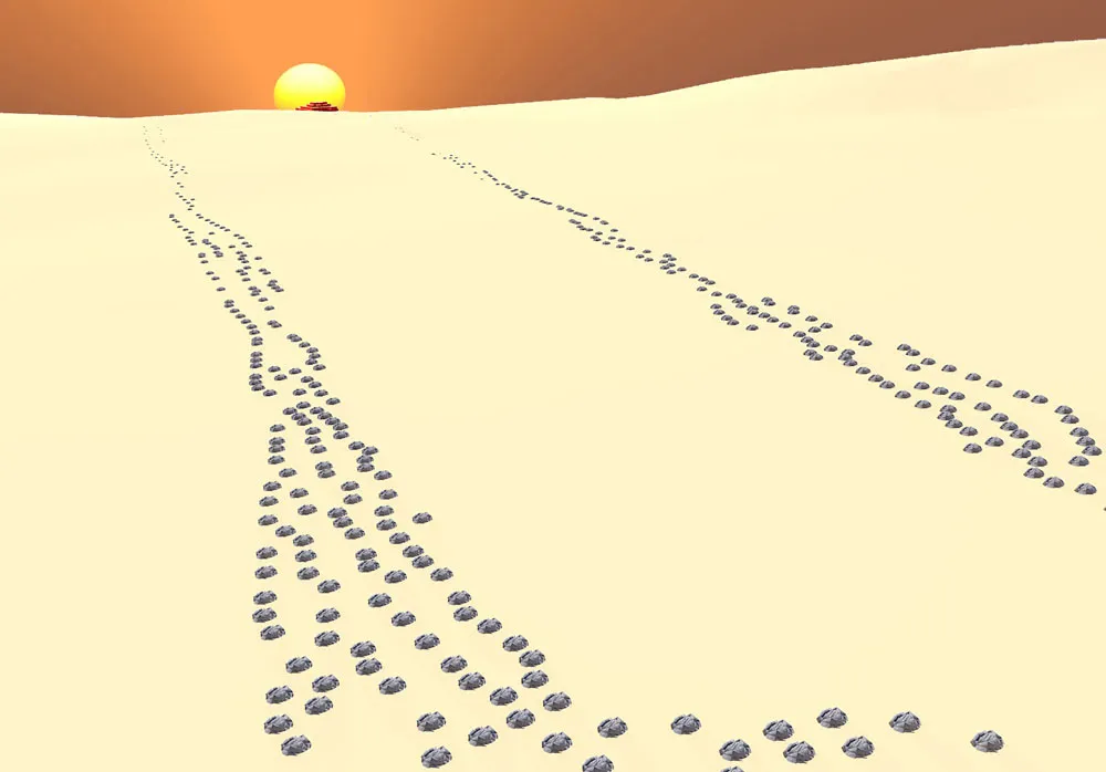
Pyramid map

This map shows the location of the stone lines (also called geoglyphs) along with cairns. The two lines which frame the Cerro del Gentil pyramid, as well as the setting winter solstice sun, are highlighted. [Read full story]
Stone lines

Researchers have found about 50 of these stone lines, the longest of which runs close to nearly 1 mile (1,500 meters). Many of these lines point to nearby settlements and their pyramids. The lines date to somewhere between 500 B.C. and A.D. 400. [Read full story]
Lengthy lines

The stone lines are seen in the distance in this photograph. [Read full story]
Piles of stone

Small rock piles forming lines. These are not cairns, the researchers said. [Read full story]
Rock piles

In addition researchers found more than 200 cairns (rock piles) inter-mixed with the stone lines. They were not used for burial. The biggest examples are 50 feet (15 meters) in diameter. [Read full story]
Working against time

The lines and cairns are being destroyed by modern-day construction. Researchers say that this image shows bulldozers from Peru's Ministry of Energy. The blue sign is from the Ministry of Culture and says that this is a protected archaeological area. [Read full story]
Near Nazca Lines

The site of Cerro del Gentil is located in southern Peru not far from the site of Nazca and its famous lines. [Read full story]