













New Satellite Provides 'Breathtaking' Views Inside Storms

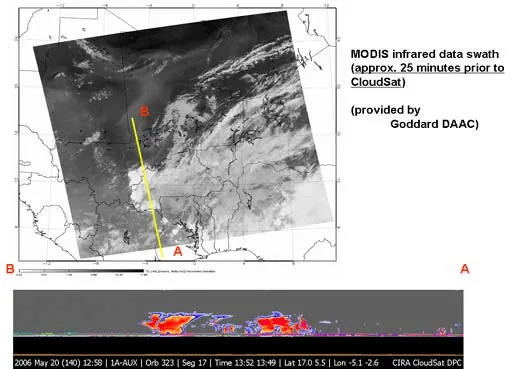
New images from a recently launched radar satellite show the promise of providing unprecedented views inside storms all around the globe.
NASA's new CloudSat satellite reveals never-before-seen details of both the clouds and precipitation within a storm, from the Earth's surface to 19 miles high.
"We're seeing the atmosphere as we've never seen it before," said Deborah Vane, CloudSat deputy principal investigator at NASA's Jet Propulsion Laboratory. "We're no longer looking at clouds like images on a flat piece of paper, but instead we're peering into the clouds and seeing their layered complexity."
The early images are test runs only, but already researchers are excited.
'Breathtaking new views'
"Although the data are still very preliminary, it provided breathtaking new views of the weather on our planet," said Graeme Stephens, CloudSat principal investigator and a professor at Colorado State University. "All major cloud system types were observed, and the radar demonstrated its ability to penetrate through almost all but the heaviest rainfall.
CloudSat's first image peered inside a warm storm front over the North Sea in the North Atlantic approaching Greenland. Another shows high-rising thunderstorms in Africa.
Get the world’s most fascinating discoveries delivered straight to your inbox.
The satellite also provided the first detailed radar views of clouds and snowstorms in the Antarctic. Until now, clouds around the poles have been hard to observe, particularly during the polar winter when it is dark around the clock.
The first validated science data from CloudSat will likely be released in a month or two, Stephens told LiveScience.
The satellite is not expected to contribute to hurricane forecasting this year, Stephens said, but its data will likely be incorporated into computer models in the future. CloudSat circles the planet every 90 minutes on a preprogrammed, ever-changing route. It cannot be redirected to image specific storms. And since it images just a vertical slice of the atmosphere [See NASA animation], an entire storm is not observed.
'Major surprises'
Where CloudSat will really shine is in revealing secrets from inside storms that will improve overall weather and climate prediction.
CloudSat works in the millimeter wavelength range. It is at least a thousand times more sensitive than any other satellite-based radar. And, unlike ground-based radar stations which have limited range, CloudSat can observe storms in the middle of an ocean.
"It allows us to see the clouds and the rain as it develops inside the storm," Stephens said. "Current radars only show the areas where it's raining."
CloudSat was launched April 28 from Vandenberg Air Force Base, Calif. It is paired with NASA's Cloud-Aerosol Lidar and Infrared Pathfinder Satellite Observations satellite to offer multiple ways of investigating the same storms.
"I think we're in for a lot of major surprises in terms of how storms produce rain," Stephens said.

Robert is an independent health and science journalist and writer based in Phoenix, Arizona. He is a former editor-in-chief of Live Science with over 20 years of experience as a reporter and editor. He has worked on websites such as Space.com and Tom's Guide, and is a contributor on Medium, covering how we age and how to optimize the mind and body through time. He has a journalism degree from Humboldt State University in California.