Tonga eruption’s towering plume was the tallest in recorded history
Researchers have accurately measured the height of the eruption plume from the undersea volcano that erupted in Tonga in January. The results confirm that it is the tallest of its kind ever recorded.
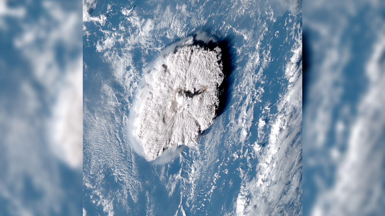
The enormous underwater volcanic eruption in Tonga earlier this year spat out the tallest plume of its kind ever recorded, a new study shows. The looming tower of ash, dust and water vapor reached 35.4 miles (57 kilometers) above sea level, and was the first plume to make it into the mesosphere — the third layer of Earth's atmosphere.
On Jan. 15, the Hunga Tonga-Hunga Ha'apai volcano, a submarine cone 40 miles (64 km) north of Tonga's main island Tongatapu, suddenly erupted. The blast was the most powerful explosion on Earth for more than 30 years, with an equivalent force of 100 Hiroshima bombs. The energetic event sparked a tsunami that reached as far as Japan and generated atmospheric shockwaves that caused the atmosphere to ring like a bell.
The colossal eruption has already shattered a number of records: The earth-shaking explosion generated the fastest atmospheric waves ever recorded, as well as triggering a record-breaking 590,000 lightning strikes. The volcano also spat out more water vapor than any other eruption on record, which could potentially weaken the ozone layer and warm the planet for years.
Now a new study, published Nov. 4 in the journal Science, has found that the volcano's plume was the tallest ever recorded, peaking at a lofty 35.4 miles. The previous record holder was the 1991 eruption of Mount Pinatubo in the Philippines, which extended 24.9 miles (40 km) above sea level at its highest point. The Tonga plume was also the first one to exceed the stratosphere — the atmosphere's second layer that spans between 7.5 and 31 miles (12 and 50 km) — and into the mesosphere, which spans between 31 and 50 miles (80 km).
Related: Undersea 'sharkcano' eruption captured in spectacular satellite images
"It's an extraordinary result as we have never seen a cloud of any type this tall before," lead study author Simon Proud, an atmospheric scientist at the University of Oxford in the U.K., said in a statement.
Volcano experts were already confident that the Tonga eruption was the tallest of its kind. However, determining the eruption plume's exact height proved to be very challenging.
Get the world’s most fascinating discoveries delivered straight to your inbox.
Normally, researchers calculate the height of a volcanic plume by measuring the temperature at its peak using infrared sensors onboard Earth-orbiting satellites and comparing it to the surrounding air temperature.
For most eruptions, the plumes only reach into the troposphere — the first layer of the atmosphere that reaches 7.5 miles above sea level — and the lower stratosphere. At this height, the air temperature profile is very predictable because the temperature decreases with altitude, which makes it easy to measure the plume's height.
However, higher up in the stratosphere, the air temperature is warmer as ultraviolet radiation gets trapped by the ozone layer, which is located at the upper boundary of the stratosphere. The air temperature then drastically plummets again in the mesosphere, which makes it almost impossible to accurately pinpoint the height of the Tonga plume using this method, researchers wrote in the statement.
To get around this problem, researchers created a new method based on a phenomenon known as "the parallax effect" — the apparent difference in an object’s position when viewed from multiple lines of sight, similar to how objects "move around" when you open one eye and then another.
The researchers used aerial images from three different geostationary weather satellites, which each captured images of the plume at 10-minute intervals, to triangulate the exact height of the plume's summit. This enabled the team to not only work out the maximum height of the plume but also see how it grew over time.
The researchers say that the new method is possible thanks to recent advancements in weather satellites. "The ability to estimate the height in the way we did is only possible now that we have good satellite coverage," Proud said. "It wouldn't have been possible a decade or so ago."
The team's new method can also be applied to other eruptions, regardless of their size, which will help researchers to standardize how they measure volcanic plumes.
"We'd like to apply this technique to other eruptions and develop a dataset of plume heights that can be used by volcanologists and atmospheric scientists to model the dispersion of volcanic ash in the atmosphere," study co-author Andrew Prata, an atmospheric scientist at the University of Oxford who specializes in studying volcanic plumes, said in the statement.
Understanding the heights of volcanic plumes will help researchers figure out how they impact climate change, researchers wrote in the statement.

Harry is a U.K.-based senior staff writer at Live Science. He studied marine biology at the University of Exeter before training to become a journalist. He covers a wide range of topics including space exploration, planetary science, space weather, climate change, animal behavior and paleontology. His recent work on the solar maximum won "best space submission" at the 2024 Aerospace Media Awards and was shortlisted in the "top scoop" category at the NCTJ Awards for Excellence in 2023. He also writes Live Science's weekly Earth from space series.
 Live Science Plus


