
 Live Science Plus


'Bomb cyclone' bringing high winds to West Coast seen from space in stunning timelapse
A low-pressure system will bring extreme gales and heavy rain to the West Coast over the next three days.

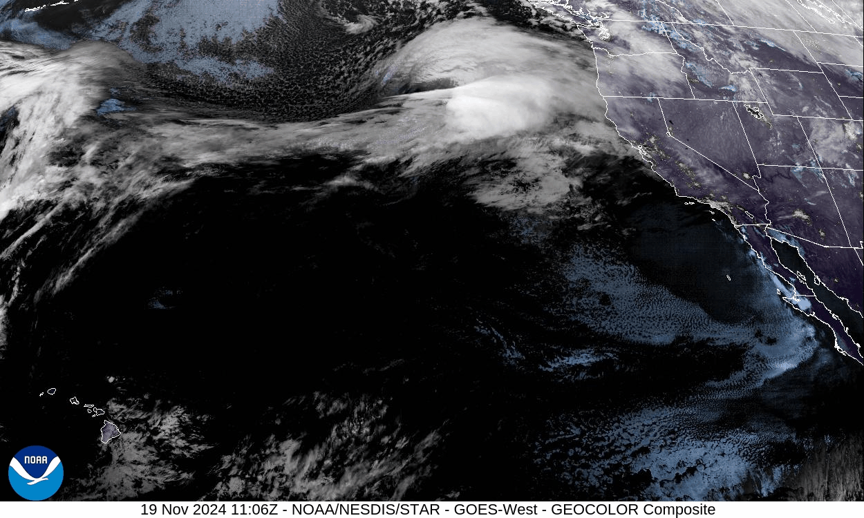
A weather satellite has captured a stunning timelapse of the "bomb cyclone" that is set to bring hurricane-like conditions to the West Coast between today (Nov. 19) and Thursday (Nov. 21).
The National Oceanic and Atmospheric Administration's (NOAA) Geostationary Operational Environmental Satellite (GOES)-West satellite captured the images of the oncoming weather system on Tuesday (Nov. 19) morning.
The storm is set to lash northern California, Oregon and Washington with powerful winds, flash floods and heavy rain and snowfall as it rapidly intensifies through a process known as "bombogenesis."
The cyclone's rate of intensification means it could be "one of the strongest low-pressure systems on record in the region," Daniel Swain, a climate scientist at the Institute of the Environment and Sustainability at the University of California, Los Angeles, wrote on the social platform X. "This very strong low will generate hurricane-force sustained winds well offshore,” generating waves up to 60 feet (18 meters) in height, he added.
Related: Hurricane Milton is tied for the fastest-forming Category 5 hurricane on record. It could become the new normal.
Bomb cyclones form when warm and cold air masses collide head-on, causing pressures to drop and storms to rapidly intensify. These low-pressure zones also pull tropical moisture northward via atmospheric rivers, leading to intense rainfall.
RELATED STORIES
It's unclear what role climate change plays in the intensification of storms such as this one, but scientists said that warming oceans are increasing the moisture drawn up into the atmosphere and giving weather systems increased boosts of energy.
Get the world’s most fascinating discoveries delivered straight to your inbox.
"There's more moisture in the atmosphere, so there's more moisture that falls out of it," Chris Brierley, a professor of climate science at University College London, told Newsweek. "The [increased] severity is something we have projected for quite a while, and is something that we're seeing across the board with storms — that when it rains, it rains more, just purely from a thermodynamic response of a warmer atmosphere and a higher saturation of vapor pressure."

Ben Turner is a U.K. based writer and editor at Live Science. He covers physics and astronomy, tech and climate change. He graduated from University College London with a degree in particle physics before training as a journalist. When he's not writing, Ben enjoys reading literature, playing the guitar and embarrassing himself with chess.