It's quick and easy to access Live Science Plus, simply enter your email below. We'll send you a confirmation and sign you up for our daily newsletter, keeping you up to date with the latest science news.
Get the world’s most fascinating discoveries delivered straight to your inbox.
You are now subscribed
Your newsletter sign-up was successful
Want to add more newsletters?
Join the club
Get full access to premium articles, exclusive features and a growing list of member rewards.
An account already exists for this email address, please log in.
El Niño is officially here, scientists say
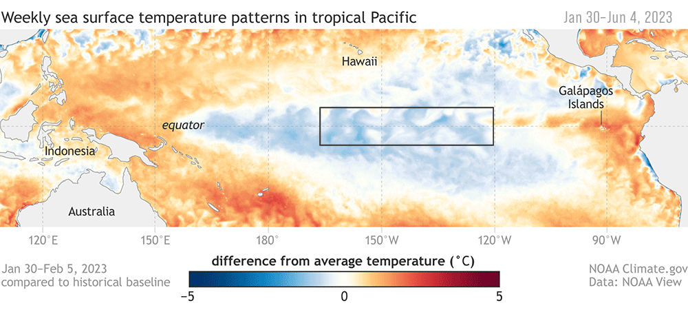
After months of warning, experts have confirmed that the ocean-warming event El Niño is here and will gradually strengthen into the winter, with a potential worldwide climate impact.
After months of anticipation, the ocean-warming event known as El Niño is officially here and could last until 2024, scientists at the National Oceanic and Atmospheric Administration (NOAA) announced Thursday (June 8).
El Niño events usually occur every two to seven years and are characterized by warmer-than-average sea surface temperatures around the equator in the central and eastern Pacific Ocean. But these events can be felt globally.
"Depending on its strength, El Niño can cause a range of impacts, such as increasing the risk of heavy rainfall and droughts in certain locations around the world," Michelle L'Heureux, a physical scientist at NOAA's Climate Prediction Center, said in a statement. "El Niño could lead to new records for temperatures, particularly in areas that already experience above-average temperatures during El Niño."
Experts have suspected an El Niño this year for some time. A NASA satellite spotted an early sign of El Niño forming in March and April: warm water in the Pacific Ocean moving eastward toward the west coast of South America.
Scientists now expect "moderate-to-strong" conditions lasting into the Northern Hemisphere's fall and winter.
Sign up for the Live Science daily newsletter now
Get the world’s most fascinating discoveries delivered straight to your inbox.
Typically, moderate-to-strong El Niño events mainly affect U.S. weather in the winter, bringing wetter-than-average conditions from Southern California to the Gulf Coast and drier-than-average conditions in the Pacific Northwest and Ohio Valley. This year's event spells warmer temperatures than usual across the northern half of the country.
El Niño also affects the chance of hurricanes, usually helping to suppress hurricane activity in the Atlantic and enhancing it in the central and eastern Pacific basins, according to the statement.
The last El Niño event occurred between February and August 2019, but its impacts were relatively weak.
Average air temperatures tend to be higher in El Niño years than in other years, with far-reaching consequences for global weather patterns. This is compounded by the effects of climate change, which can exacerbate or mitigate certain effects of El Niño, L'Heureux said.
Sascha is a U.K.-based staff writer at Live Science. She holds a bachelor’s degree in biology from the University of Southampton in England and a master’s degree in science communication from Imperial College London. Her work has appeared in The Guardian and the health website Zoe. Besides writing, she enjoys playing tennis, bread-making and browsing second-hand shops for hidden gems.

 Live Science Plus