This ScienceLives article was provided to LiveScience in partnership with the National Science Foundation.
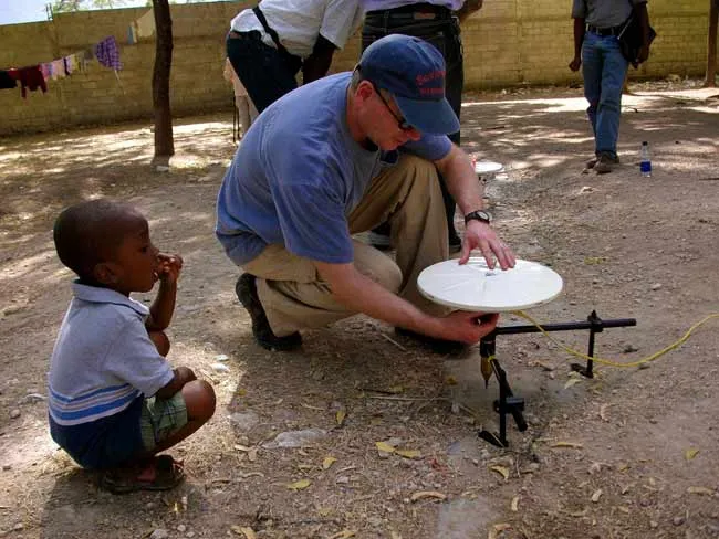
Andrew Freed, an associate professor of geophysics at Purdue University, seeks to understand the evolution of stresses in the crust before, during and after earthquakes. Knowledge of where stresses are building the fastest or which faults currently support the highest unrelieved stress are valuable in estimating current seismic hazards, including continuing hazards in Haiti. Freed uses measurements of surface deformation from highly sensitive GPS receivers to constrain numerical models of earthquake and plate-tectonic processes. Such models have been used to, amongst other things, understand how one earthquake can lead to another on a nearby fault and how warm rocks below the surface flow following earthquakes. Freed also uses numerical models to study the mechanics of the crust on other planets and is currently using new observations from the MESSENGER spacecraft to understand the tectonics of Mercury. Read about Freed’s recent experience conducting fieldwork in Haiti following the January 12, 2010 earthquake; learn about the latest updates on the Haitian humanitarian situation, failed buildings, and geologic threats in the Learning from Haiti website; and learn more about researcher experiences in Haiti at the NSF Geophysicists in Haiti Blog. For Freed’s answers to the ScienceLives 10 questions, see below.
Name: Andrew Freed Age: 48 Institution: Purdue University Field of Study: Geophysics – earthquake hazards
Latest Videos From
What inspired you to choose this field of study? The first earthquake I experienced made me realize just how remarkable (and humbling) the power of nature can be. Once I learned that earthquakes occurred in clusters, I realized that the faults were talking to each other and I wanted to listen in.
What is the best piece of advice you ever received? Do what you enjoy and the rest will take care of itself.
What was your first scientific experiment as a child? Determining the best trajectory to launch a toy soldier with a bottle rocket to achieve the longest distance (my mom still doesn't know).
What is your favorite thing about being a scientist or researcher? I love an academic life that allows me to conduct research that interests me, mentor graduate students, teach non-science undergraduates about the wonders of the natural world, and be involved with great scientific and campus communities, yet affords me time with my family and the freedom to travel. What more could someone want in a job?
What is the most important characteristic a scientist must demonstrate in order to be an effective scientist? There are two: persistence and objectivity. Without both of these traits a scientist will have a difficult time uncovering the truth.
What are the societal benefits of your research? My research focuses on trying to understand seismic hazards. While this research may never lead to the prediction of when an earthquake will occur, we are getting good at determining where and how big.
Who has had the most influence on your thinking as a researcher? I have been extremely fortunate to have three amazing advisers (Jian Lin, Jay Melosh, and Roland Bürgmann) who taught me how to choose good lines of research, how to be an effective communicator and the importance of being collegial.
What about your field or being a scientist do you think would surprise people the most? There is a saying I once heard: When you earn a Bachelor of Science you think you know everything. When you earn a Master of Science you realize you don't know anything. And when you earn a Ph.D. you realize that nobody else knows anything either. I think most people would be surprised to learn how much there is to understand about nature and how little we actually know.
If you could only rescue one thing from your burning office or lab, what would it be? I would rescue the artwork done by my kids. Everything else is backed up.
What music do you play most often in your lab or car? Classic rock: Pink Floyd, Led Zeppelin, The Beatles, Bruce Springsteen …
Editor's Note: This research was supported by the National Science Foundation (NSF), the federal agency charged with funding basic research and education across all fields of science and engineering. Any opinions, findings, and conclusions or recommendations expressed in this material are those of the author and do not necessarily reflect the views of the National Science Foundation. See the ScienceLives archive.

 Live Science Plus