The raindrops that patter onto roofs, sidewalks and umbrellas during a shower or storm fall in a wide range of sizes, as anyone who pays attention can see. The explanation for this variety turns out to be much simpler than scientists thought.
Experts have long thought that the size differences observed in natural raindrops was due to the same complex interactions of droplets that form raindrops in clouds. But a new study finds that the best explanation for the motley size assortment is that the raindrops released from the clouds break up into smaller drops as they fall.
Rain forms in clouds as water vapor gloms onto dust or other tiny particles, gradually building up. Because these infant drops are relatively packed together in the cloud, they collide with one another and coalesce into larger drops. The turbulent air inside a storm cloud can aide the process.
Latest Videos From
It was presumed that this same process of collision kept up on the fall to the ground, resulting in some drops being bigger or smaller than others.
But a team of French scientists had another idea.
For the collision proposal to work, the falling raindrops would have to be close enough to collide frequently enough and they would need enough time to do so, Emmanuel Villermaux and Benjamin Bossa, both of Aix-Marseille Université, wrote in their study, which is detailed online on July 20 in the journal Nature Physics. They consider these conditions "unlikely."
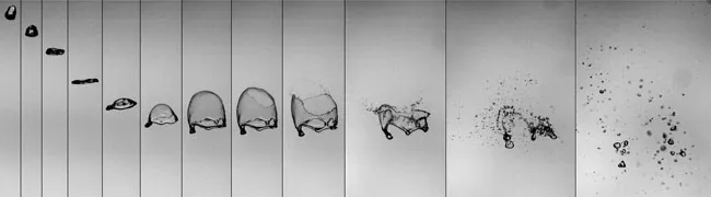
Instead, by analyzing high-speed movies of falling water droplets, Villermaux and Bossa found that the drops go through a series of shape-shifting moves and finally burst apart into a spray of multi-sized drops.
First, the falling spherical drop gradually flattens out into a pancake shape. As it gets wider and thinner, it eventually captures the air ahead of it and deforms into a shape something like an upturned plastic grocery bag, the study shows.
When the inflated "bag" reaches a certain size, it breaks apart into many smaller droplets, which fall to the ground and get you wet. The distribution of droplets that result from the burst matches the variation seen in natural rainfall, the team reported.
This model of droplet burst was known in other contexts, such as diesel engines and liquid propellant combustion, but had never been applied to rain.
"The atmospheric science community simply had another scenario in mind, and didn't make the connection," Villermaux told LiveScience in an email.
Asked whether this new finding would change any weather prediction models, Villermaux said it would not.
Now that they've seen this process at work in liquid droplets, the scientists are curious as to whether it works in brittle solids as well, specifically, in snowflakes.