It's quick and easy to access Live Science Plus, simply enter your email below. We'll send you a confirmation and sign you up for our daily newsletter, keeping you up to date with the latest science news.
A satellite launched in September, NASA's ICESat-2 ,or the Ice, Cloud and Land Elevation Satellite-2, is revealing previously unmapped valleys in Antarctica, filling in details of the terrian that other satellites can't see. But ICESat-2 isn't only out to create ice sheet maps; it is also gathering information on other parts of the world, including the heights of land terrain, rivers, lakes and forests, as well as the depth of seafloors.
Initial data shows that the satellite can measure slopes steeper than 45 degrees throughout the Transantarctic Mountains that run between East and West Antarctica. Over the Antarctic Ice Sheet, it can measure narrow openings in the ice 65 feet (20 meters) deep and it can distinguish between thin ice, thick ice and ice ridges, according to NASA.
But this is just the very start: After ICESat-2 gathers more data, the scientists will be able to use it to fill in more details in older maps of Antarctica and show elevation changes of ice sheets and glaciers through time. This data can help them improve sea-ice and climate forcasts, according to NASA.
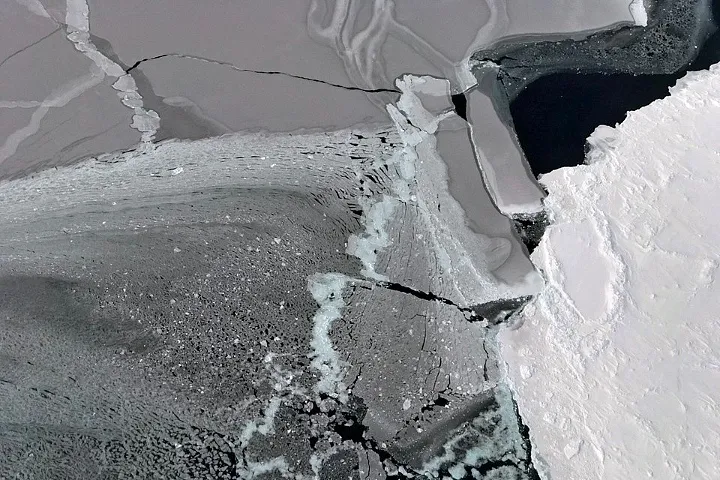
NASA's ICESat-2 measures changes in elevation with such precision that it can help scientists distinguish between thin and thick sea ice. It can also pick up on leads, which are cracks between ice floes.
(Image credit: NASA Earth Observatory/Joshua Stevens)
The satellite works by firing a laser, which splits into six beams, all of which hit the Earth and then bounce back. Some of the photons from the light make it back to the satellite — and the time it takes for them to do so serves as a measure of the elevation of the spot the light hit. The measurements are super-precise, down to the nearest billionth of a second, according to Live Science's sister site Space.com. This satellite also has a bit of backup closer to the ground— NASA has been flying over the same paths of the satellite to make sure the measurements are accurate.
And because the satellite never stops collecting data, it also picks up details from other parts of the world, including waves in the oceans and trees in the forests. It can precisely measure the depth of coastlines and the height of tree canopies. Mapping trees and the land below may help improve scientists' understanding of how much carbon forests can hold.
Yasemin is a staff writer at Live Science, covering health, neuroscience and biology. Her work has appeared in Scientific American, Science and the San Jose Mercury News. She has a bachelor's degree in biomedical engineering from the University of Connecticut and a graduate certificate in science communication from the University of California, Santa Cruz.

 Live Science Plus