


Cloud Cover Reveals Continents
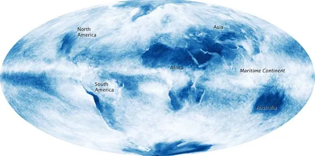
The difference in cloud cover over land vs. the oceans can be so stark that outlines of the continents are revealed in space-based observations of clouds only.
The trick is illustrated in a new image from NASA, taken last month and released today. It is an image that shows "cloud fraction," or the fraction of an area covered by clouds.
The measurements were collected by the Moderate Resolution Imaging Spectroradiometer (MODIS) on NASA's Terra satellite. Colors range from blue (no clouds) to white (totally cloudy).
Not surprisingly, the most dramatic cloud boundaries occur in places where very dry land is surrounded by ocean, such as northern and southern Africa, the Arabian Peninsula (east of North Africa), and Greenland, the space agency explained in a statement. The sharp boundary between water and land fades over humid regions. In west-central Africa, the contour of the coastline fades beneath clouds that are nearly as prevalent over the humid tropical forests as they are over the Atlantic Ocean to the west.
Over the islands, narrow peninsulas, and shallow seas between Southeast Asia and Australia, the difference between land and water virtually disappears; the entire region is extremely cloudy, and the outlines of the major land masses—including the Indonesia islands of Sumatra and Borneo are barely perceptible. This blurring of boundaries is reflected in the name meteorologists give this region: the Maritime Continent.
In addition to their role as rain- and snow-makers, clouds are often the arbiters of energy entering and leaving the climate system. Clouds may have a warming or cooling influence depending on their altitude, type, and when they form. Clouds reflect sunlight back into space, which causes cooling. But they can also absorb heat that radiates from the Earth's surface, preventing it from freely escaping to space. The diversity of roles clouds can play makes daily, global observations vital to understanding and predicting our climate.
- Gallery: Curious Clouds
- Gallery: Sky Scenes
- Planet Earth: A Portrait
Get the world’s most fascinating discoveries delivered straight to your inbox.
