
 Live Science Plus


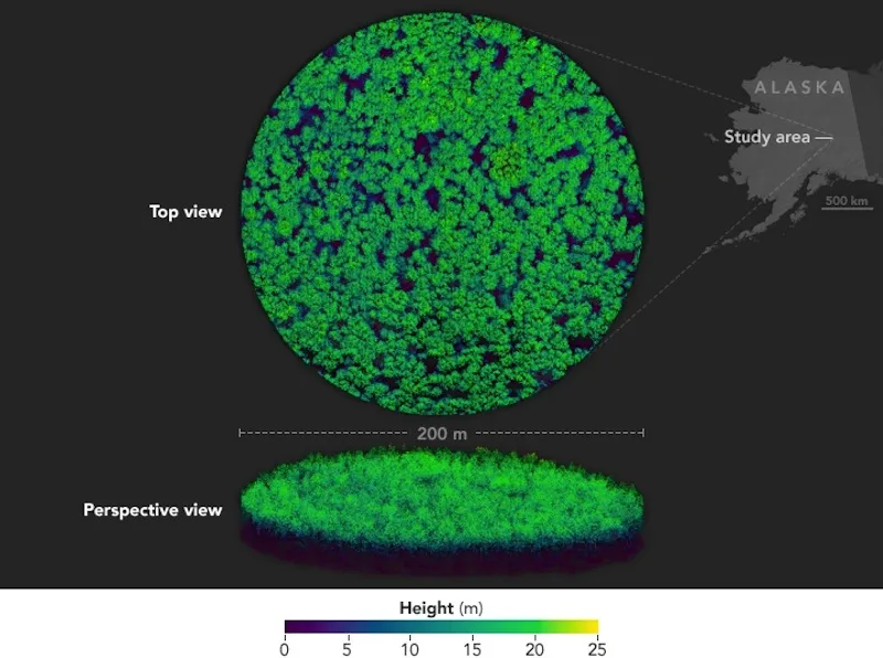
Unique 3D Views of Alaskan Forest Captured with Laser Scanner

Scientists are zeroing in on a slice of forest in Alaska, using a powerful laser scanner to probe the area and produce unique 3D views of the trees that call the forest home.
Earlier this month, scientists working on NASA’s ABoVE field campaign performed ground surveys of a birch forest in the Tanana Valley of interior Alaska. The ground surveys complement data collected in 2014 using the so-called G-LiHT airborne imager, which produces views that can't be achieved using satellite imagery alone.
In a newly released 3D image, varying colors correspond to different tree heights. Shades of yellow represent the tops of the tallest trees (measuring up 82 feet or 25 meters), while the dark-purple shade represents the ground, according to NASA's Earth Observatory. This technique makes it easy for scientists to see that most of the trees in this forest are of uniform height, the agency said. [Photos: Get a Rare Glimpse of Remote Alaska]

G-LiHT, short for Goddard’s lidar, Hyperspectral and Thermal imager, is known as an imaging spectrometer, and is capable of collecting three different types of data to study the composition of the forest. Lidar, responsible for making the image 3D, stands for light detection and ranging, and is a remote-sensing method (similar to radar, which employs radio waves) that uses pulsed laser light to measure ranges.
Hyperspectral cameras can collect image data far outside the spectral range of the human eye. The electromagnetic spectrum spans low frequency waves (like microwaves) to gamma rays, which are high frequency. The visible light spectrum is a small segment that falls on the shorter end of the spectrum, and contains the wavelengths that humans can see.
A normal color camera acquires three different spectral channels that correspond to the visual primary colors: red, green, and blue. Hyperspectral imaging can acquire the light intensity for up to several hundred contiguous spectral bands, according to Norsk Elektro Optikk, a privately owned electro optics research company in Norway. This means the camera can pick up information from wavelengths that can't be seen with the naked eye. This sort of data can help researchers accurately characterize and classify objects — in this case, the Alaskan birch trees.

G-LiHT also has an infrared thermal camera to detect heat. This can help scientists identify trees that are infested with insects, because these trees will appear to glow with warmth in the thermal images, according to NASA.
G-LiHT’s various capabilities function in tandem and communicate data just like the senses do in the human nervous system, Bruce Cook, an Earth scientist at NASA's Goddard Space Flight Center, told Phys Org. "One sense cannot totally inform you," Cook said. "A more complete picture of forest composition and health can be obtained with multisensor instrument packages."
In 2015, the technology was used in forests in the northeastern United States to monitor damage to pine and ash trees by two types of ravenous insects: the emerald ash borer and the southern pine beetle. G-LiHT can help map at-risk areas by detecting the location of the bugs.
Currently, the ABoVE team is re-surveying the Tanana Valley to assess the ecological impacts of climate change. Thawing permafrost, wildfires and changes to wildlife habitats are affecting Alaska and northwestern Canada, according to the Earth Observatory. The birch forest acts as a living data set, and when it is periodically monitored, the trees offer a continuous record of a dynamic ecosystem, the agency added.
Original article on Live Science.
