
 Live Science Plus


Southern High Plains: Needed Rain to Follow Fire Danger
This article was provided by AccuWeather.com.
While the week will start with a high fire danger across the southern High Plains, days of welcome rainfall are on the horizon.
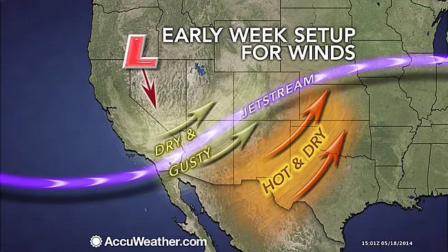
Gusty winds will howl daily through Tuesday from the deserts of California to West Texas as a storm system slowly sinks across the West.

The winds will occasionally gust between 30 and 45 mph, especially during the afternoon and early evening hours.
With the ongoing drought, heat and very low humidity, the winds have greatly elevated the fire danger. Parts of West Texas and southeastern New Mexico will crack the century mark Monday and Tuesday.
Extreme care should be taken with campfires, cigarette butts and outdoor power equipment. Among those who should heed this advice are residents in the following cities: Flagstaff and Tucson, Arizona, Albuquerque and Las Cruces, New Mexico, and El Paso, Lubbock and Amarillo, Texas.
The winds also threaten to kick up blowing dust, which would dramatically reduce visibility for motorists. Blowing dust has been the culprit behind numerous multi-vehicle accidents across the Desert Southwest in the past.
Get the world’s most fascinating discoveries delivered straight to your inbox.
RELATED: Forecast Temperature Map Fire Weather-Related Watches, Warnings Ken Clark's Western Weather Blog
Those planning to travel on stretches of I-10, I-25, I-27 and I-40 should use caution and allow ample stopping distance between the vehicle you are following.
The same storm system whipping up the gusty winds is also likely to produce rounds of locally drenching showers and thunderstorms later this week through the Memorial Day holiday weekend across eastern New Mexico, West Texas, western Oklahoma, parts of Kansas and eastern Colorado.
Such prospect of rain is extremely good news with the southern High Plains in the midst of a severe drought.
The U.S. Drought Monitor has classified the drought as exceptional across nearly 21 percent of Texas and close to 30.5 percent of Oklahoma. The majority of this area lies in the Texas Panhandle and western Oklahoma.
Above was the status on the drought across the south-central U.S., which was released by the U.S. Drought Monitor on May 15, 2014. The dark red indicates where an exceptional drought is under way.
Data from the National Weather Service Office in Lubbock, Texas, indicates that the 43 month period from October 2010 to April 2014 is the driest on record, shattering the previous driest stretch that ended on April 30, 1955, by 8.64 inches.
Lubbock and Amarillo have yet to receive any measurable rainfall so far this month. In a typical May, both cities would have recorded an inch or slightly more by May 17.
Amid the beneficial aspects of the upcoming rain, there are a few hazards that residents should be alerted to.
Enough rain could pour down to trigger localized flash flooding. The ground, which has hardened during the drought, may have difficulty absorbing the rain water.
Flash flooding will also become a concern underneath any showers and thunderstorms that are slow-moving or track over the same location repeatedly.
The storminess could also interfere with Memorial Day festivities. Remember, you are close enough to be struck by lightning if you hear thunder.
An outbreak of severe weather is not expected. However, a few stronger thunderstorms with damaging winds and hail can erupt. That may be especially true at the onset of the thunderstorms Wednesday and Thursday.
AccuWeather.com. All rights reserved. More from AccuWeather.com.