Hunting Uncharted Undersea Mountains, From Space

Maps lie. Or, at least, they contain a whole lot of guesswork.
The view of Earth's ocean bottoms, for example, on Google Earth or some other global map gives you the impression we have the seafloors completely charted. But there are huge guesses regarding what's under the waves for the about 90 percent of the world's oceans that have not been directly mapped by ships using sonar.
That's why an improvement on an unusual method to see under the waves from space is such a big deal. The new method was presented at the Ocean Science Meeting last week in Honolulu.
PHOTOS: Changing Face of Earth in 2013
“When you go into Google Earth and look at sea floors, you see two things,” said ocean gravity mapper David Sandwell of the Scripps Institution of Oceanography at the University of California at San Diego. “One is the predicted depth and structure from gravity measurements. Two is that every once in a while you'll see a clear strip with more detail.”
Those rare strips are where a research ship has actually motored over and measured the seafloor bathymetry.
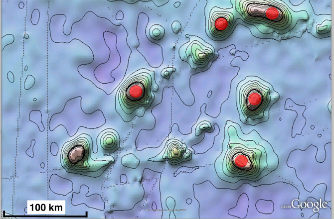
Where ships haven't mapped the seafloor, the job has been left to satellites, particularly those that can measure heights of the seas. Those satellites essentially “feel” the gravitational effects of undersea mountains. New satellite sea surface altimetry datasets are enabling scientists to see smaller and smaller mountains that rise from the sea floor (known as seamounts), but remain hidden by the oceans.
Get the world’s most fascinating discoveries delivered straight to your inbox.
NEWS: Gravity Satellite Felt Japan Quake from Space
“The ocean surface will have a bunch of waves and other temporal changes,” said Seung-Sep Kim of Chungnam National University in South Korea. “The seamounts create a (permanent and very subtle) bump. They can only be seen by satellite.”
This bump can be translated into a gravity measurement of a seamount, which gives an indication of its size.
Kim and his colleagues reported on Feb. 28 that they have successfully tested new sea surface altimetry data from the Earth-observing satellites CryoSat-2, Envisat and Jason-1 on a known seamount to see how well it worked. The triple dataset is a huge improvement on the older altimetry data that for some time consisted of a single satellite. Now it can be used to reduce the guesswork in the bathymetry maps with which the general public is familiar.
“CryoSat is the most important,” said Sandwell. “It's designed to measure ice volume changes, but it's also a really super ocean altimeter.”
ANALYSIS: Twitter: GOCE Burned Up Over Falkland Islands
The ocean altimeters are also much better at seamount detection than satellites like GRACE (a twin satellie mission that has been taking data since 2002) and GOCE (which finished its gravity-mapping mission and reentered in 2013) that directly measure dips and bumps in Earth's gravity -- another indication of mountains and other significant features on the seabed.
The reason, said Sandwell, is that GRACE is 400 kilometers (250 miles) above the surface of the Earth. Because the force of gravity tapers off quickly with altitude, the resolution of the gravity map GRACE generates is only as precise as its distance from the Earth. GOCE orbited 200 kilometers (124 miles) up, which means a factor of 2 better resolution than GRACE, but that's still an altitude at which most seamounts will remain undetected.
The sea surface, on the other hand, is only a few kilometers above the sea floor, so its resolution is on the scale of a few kilometers -- which means unknown seamounts will have a hard time hiding.
This story was provided by Discovery News.


