
 Live Science Plus


Widespread Damage to Syria's Ruins Seen from Space

Archaeologist Jesse Casana couldn't have foreseen the violence that would break out in Syria less than a year after he left his dig site in summer 2010.
"No one knew whether it was going to blow over quickly," Casana said. "We were all just waiting to see what happened. Clearly, it started getting worse."
Casana, a professor at the University of Arkansas, was director of an expedition at Tell Qarqur, an artificial mound in northwest Syria built up through 10,000 years' worth of debris left by human occupation. He had to cancel his 2011 field season, and because of the ongoing war in Syria, he hasn't returned since. Violence has besieged the Christian village of Gassanieh, where his team stayed, and he has barely been able to contact his friends and colleagues in the country, let alone get a handle on how Tell Qarqur is faring.

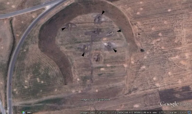
Images from Google Earth, however, show pretty clearly what's been going on: By July 2011, tanks were sitting inside bunkers carved into the top of the mound. Apparently, the prominent surfaces of ancient mounds built over several millennia can also serve as strategic grounds for military installations overlooking the flat surroundings. [Photos: Damage to Syrian Ruins Seen from Space]
Destruction from above
Activists and archaeology researchers have made ambitious attempts to assess the war's toll on cultural heritage in Syria, which was home to Paleolithic settlements, Roman outposts, and the Assyrian, Persian and Akkadian empires. But many on-the-ground reports of damage at sites in Syria have been unreliable at best, and propaganda-driven at worst, circulated by citizen journalists, amateur photographers and members of the Bashar al-Assad regime, Casana noted.
The impartial eye of satellites, however, could help archaeologists assess, or at least verify, which sites are at risk when conflict makes countries like Syria otherwise inaccessible.
Get the world’s most fascinating discoveries delivered straight to your inbox.
Casana, who is also chairman of the American Schools of Oriental Research's Damascus Committee, presented the results of a small survey this month at the annual meeting of the Archaeological Institute of America in Chicago. With recent satellite images from the DigitalGlobe, a company that provides high-resolution Earth imagery, Casana analyzed 30 sites across Syria and found moderate to severe war-related damage and looting at 10 of them.
But the breadth of the destruction is likely much worse. Satellite photos don't reveal localized scars of shelling on monuments and architecture. Of the 20 sites where no visible destruction showed up in the imagery, six had well-documented war-related damage on the ground, Casana said. [7 Stunning Archaeological Sites in Syria]
"With the war less than three years old and no resolution in sight, it's not a really good prognosis," Casana said during his presentation. "The data really does suggest there does not seem to be any clear geographic orientation to the damage. It seems to be taking place all across Syria. But we do see a strong trend toward looting at Hellenistic, Roman or early Islamic sites in particular, I suspect, because metal or gold is more common in them."
Casana told LiveScience he estimates that at least half of the major sites in Syria are getting badly damaged by the war.
Looting holes and military bunkers

Satellite imagery shows widespread looting and destruction at some of the country's most iconic ruins, such as Apamea, a once-flourishing Roman city about an hour south of Tell Qarqur. Apamea's long column-lined street is often emblazoned on the cover of Syrian guidebooks, but a military garrison now fortifies a former tourist restaurant at the center of the site, and more than 4,000 holes dug by looters and treasure hunters are visible in the surrounding landscape. [Photos: 7 Stunning Archaeological Sites in Syria]
"Zooming closer, you can see that these are not small holes," Casana said. "Most measure 2 or 3 meters (7 to 10 feet) on the side, and many of them are bigger, suggesting that they're probably dug with the help of machinery."
Just a mile and a half (2.5 kilometers) to the east of Apamea sits a mound called Tell Jifar, which formed over many centuries of occupation, though it is unexcavated and not very well understood by archaeologists, Casana said. The mound is now topped with a military garrison and pockmarked with looting holes. Some of these pits can be spotted in images from as far back as 2007 and 2003, Casana found, suggesting many Syrian sites were hardly secure before the onset of violence.
"I was surprised by the extreme scale of looting that had already taken place prior to the war," Casana told LiveScience. He suspects the same group of looters likely brought their shovels to both Apamea and Tell Jifar because of the sites' proximity and the long history of looting at Tell Jifar. In both cases, the looting seems to have happened "with at least the tacit cooperation of military forces encamped at the sites," Casana said in a recent email.
But the Assad regime's army can't bear sole blame for the destruction at archaeological sites. On other ancient mounds in his survey, Casana said he's spotted what look like bunkers belonging to the Free Syrian Army, the opposition forces seeking to oust Assad. To help fund their insurgency, the rebels told The Washington Post last year that they've been selling looted tablets, vases and other artifacts through illicit antiquities markets in Jordan, Lebanon and Turkey.
International observers have been waiting for those valuable objects to hit bigger auction houses. The International Council of Museums, or ICOM, created a "Red List" of Syrian antiquities that should raise eyebrows if they show up on the antiquities market.
Casana says his survey was mainly a proof of concept. Free satellite images from Google Maps and Bing Maps typically haven't been updated for Syria beyond 2012, and up-to-date pictures are more expensive. This past fall, Casana received 25 satellite images of Syria that were taken over the past four to 15 months through a grant from the DigitalGlobe Foundation.
The 30 archaeological sites covered in those 25 images, however, are just a fraction of the 20,000 sites Casana initially had flagged in his database for Syria.
Follow Megan Gannon on Twitter and Google+. Follow us @livescience, Facebook & Google+. Original article on LiveScience.
