Syria Civil War Scars Seen from Space

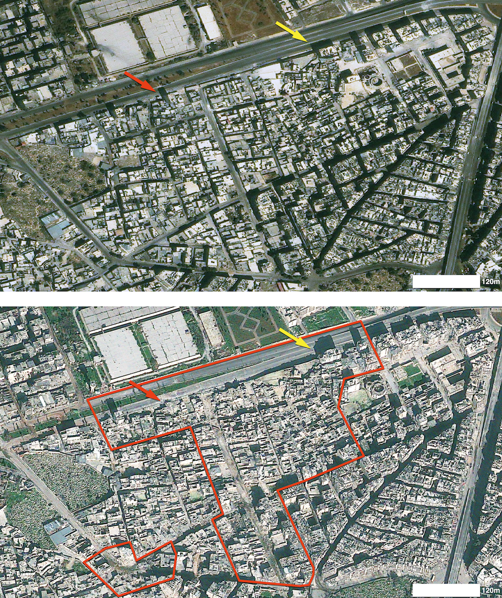
A brutal and ongoing civil war in Syria is leaving a heavy trail of destruction in its wake, with damage in the city of Aleppo so significant that scars from the conflict can be seen from space.
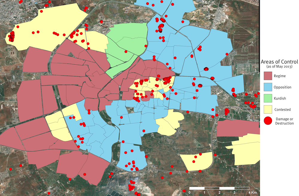
Researchers from the American Association for the Advancement of Science (AAAS) analyzed a series of high-resolution satellite images of Aleppo taken from August 2012 to May 2013. They found that visible damage to buildings and infrastructure increased over that 10-month period, with almost all of the destruction concentrated in rebel-controlled or contested areas.
The researchers also documented that Aleppo's historic city center, the Ancient City of Aleppo — a 13th century walled-in citadel that was designated as a UNESCO World Heritage Site in 1986 — has suffered extensive damage from the Syrian civil war.
"We are documenting a war zone," Susan Wolfinbarger, director of the Geospatial Technologies and Human Rights Project, said in a statement. "It's a really dangerous situation in Aleppo. There are people on the ground reporting out, but they're in specific, localized places and not able to move around freely. What we're able to do is provide a comprehensive look at the situation over time, examining the entire city and assessing what is going on throughout the area." [In Photos: Amazing Ruins of the Ancient World]
Heart of an uprising
Aleppo has been a hotbed of unrest since July 2012. Since conflict broke out between forces loyal to Syria's dominant Ba'ath government and rebel forces seeking to oust it, Aleppo has experienced an average of three destructive incidents per day, the researchers said. Signs of damage in the region include battered buildings, debris fields and craters.
In the satellite images, the researchers also observed changes to the city over time, such as the proliferation of improvised roadblocks and the increased visibility of artillery, tanks and aircraft, which suggest military activity in the area is intensifying.
Get the world’s most fascinating discoveries delivered straight to your inbox.
"It's interesting to see that the roadblocks are all across the city," Jonathan Drake, an imagery analyst for the project, said in a statement. "One might think these would be more prevalent in rebel-held areas — perhaps as defensive positions — but in fact, it appears that the highest concentrations occur where regime forces are reported to be in control."
The AAAS researchers compared nine satellite images taken at regular intervals during the 10-month period, observing 713 incidents of destruction. Even so, they noticed the distribution of damage across Syria has not been uniform.
Only six of the destructive incidents seen by the researchers occurred in districts that are reported to be under the control of forces loyal to the Syrian government. The bulk of the ruins were in areas either under rebel control, under Kurdish control, or in areas whose control is unknown.
"Though other interpretations may be possible, this striking dichotomy in damage, in conjunction with direct observations of military activity, is consistent with reports that government forces have been using aircraft, missiles and long-range artillery to bombard rebel-held areas," the researchers wrote in their report.
Violence and destruction
The Ancient City of Aleppo is situated at the crossroads of trade routes that date back to the second millennium B.C. The AAAS researchers observed damage to some ancient structures within the fortressed city, including mosques, cemeteries and several other historical sites. [Photos: Meet the Newest World Heritage Sites]
The new analysis covered approximately 70 square miles (182 square kilometers) of Aleppo and its surrounding regions. The photos, captured by a fleet of satellites, were occasionally limited by dense clusters of buildings in Aleppo, the shadows from the buildings and the viewing angles of the satellites, the researchers said.
"Despite these challenges, it was possible to observe many signs of the conflict throughout the study area," the researchers stated in the report.
On July 25, the United Nations announced that Syria's civil war has claimed more than 100,000 lives since the outbreak of fighting in 2011.
The full report by the Geospatial Technologies and Human Rights Project at the AAAS was published on Aug. 7. The independent study was done at the request of Amnesty International USA.
Follow Denise Chow on Twitter @denisechow. Follow LiveScience @livescience, Facebook & Google+. Original article on LiveScience.

Denise Chow was the assistant managing editor at Live Science before moving to NBC News as a science reporter, where she focuses on general science and climate change. Before joining the Live Science team in 2013, she spent two years as a staff writer for Space.com, writing about rocket launches and covering NASA's final three space shuttle missions. A Canadian transplant, Denise has a bachelor's degree from the University of Toronto, and a master's degree in journalism from New York University.
 Live Science Plus


