


Atlantic Expected to See Sudden Uptick in Storms
This article was provided by AccuWeather.com.
The battle between tropical waves and dry air in the Atlantic may let up in late August, leading to an increase in stronger tropical systems.
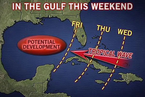
A tropical wave is moving along the Tropic of Cancer in the middle of the Atlantic Ocean. Through the middle of the week, this wave will migrate westward, reaching the Greater Antilles for the middle of the week.
It's still too early to determine whether or not this will become an organized storm. Either way, moisture along with showers and storms will move through the Caribbean. The wave could also bring some much-need rainfall to drought-stricken portions of Texas, even if the wave does not strengthen into a tropical depression or storm.
The wave has a slight chance to develop into a tropical system, especially if it can set up in the Gulf of Mexico. However, the biggest challenge will be for it to remain intact as it journeys through the western Atlantic.
This tropical wave will be face-to-face with the same limiting factors that have been hindering tropical development in the Atlantic for the past month.
A massive Saharan Dust plume continues to push off the coast of Africa, covering much of the Atlantic. The dust is associated with dry, desert air, providing the opposite of the moisture-rich habit needed for storms to strengthen.
Get the world’s most fascinating discoveries delivered straight to your inbox.

Wind shear has also been fighting the tropical waves moving across the Atlantic. High winds continue to blow from west to east, opposite of the usual pattern across the Caribbean, shredding storms that enter the region.
The most typical limiter for the early part of tropical season is water temperature. The water warms slower than the land, making late summer and early fall the time for the most favorable water temperature.
RELATED: Watch: Saharan Dust Cloud Travels Atlantic 4 Need-to-Know Changes as 2013 Hurricane Season Ramps Up AccuWeather Hurricane Center
However, recently, the water temperature has been a few degrees below average near the Antilles. Adding to the dust and shear, this has kept tropical season on lock-down.
Defeating all of these factors is close to impossible, but beating one of these features is definitely possible, AccuWeather Senior Meteorologist Mark Paquette said.
"Dorian, when it formed in the open Atlantic, overcame an atmosphere laden with Saharan dust but was not dealing with the amount of shear systems would be right now," explained Paquette.
The Atlantic Basin seems to have had a rather quiet start to tropical season this year, but not so much when compared to normal.
The average number of named storms through the beginning of August is between two and three, a number we have already reached thus far this season.

Looking ahead, storms will have the opportunity to ramp up during late August and early September. This is the average peak of tropical storms and hurricanes in the Atlantic Basin when the biggest weakening factors will die down.
"The atmosphere in the tropical Atlantic will moisten up as this cloud of Saharan dust dissipates/heads west and climatology says shear will relax as well as we go through time. As these factors go away, the amount of systems will go up as well and it could go from not busy to very busy quickly," Paquette said.
© AccuWeather.com. All rights reserved. More from AccuWeather.com.