


Best Earth Images of the Week March 8, 2013
Before the ice came

Like Alaska's mighty Yukon, a broad river once flowed across Antarctica, following a gentle valley shaped by tectonic forces at a time before the continent became encased in ice. Understanding what happened when rivers of ice later filled the valley could solve certain climate and geologic puzzles about the southernmost continent.
The valley is Lambert Graben in East Antarctica, now home to the world's largest glacier. Trapped beneath the ice, the graben (which is German for ditch or trench) is a stunning, deep gorge. But before Antarctica's deep freeze 34 million years ago, the valley was relatively flat and filled by a lazy river, leaving a riddle for geologists to decode: How did Lambert Graben get so steep, and when was it carved?
[Full Story: What Antarctica Looked Like Before the Ice]
A new view of diversity

A new photo taken from the International Space Station shows an ecologically diverse area of Panama in a new light.
The picture is the first taken by a new Earth-observing tool recently installed on the orbiting science laboratory, and shows the San Pablo River emptying into the Gulf of Montijo, reported NASA's Earth Observatory.
[Full Story: New Space Station Camera Snaps First Image of Earth]
An intimate embrace

Scientists are unveiling a rare octopus that has never been on public display before.
And unlike other octopuses, where females have a nasty habit of eating their partners during sex, Larger Pacific Striped Octopuses mate by pressing their beaks and suckers against each other in an intimate embrace.
[Full Story: Rare Kissing Octopus Unveiled For the First Time]

Snowy threat

The latest in a series of late-season snowstorms is barreling toward the East Coast, dumping nearly a foot of snow on some locales as it passes.
The National Weather Service predicts 8 to 12 inches (20 to 30 centimeters) of snow could fall in the Mid-Atlantic states tonight (March 5), with up to 18 inches (45 cm) in West Virginia. Tomorrow (March 6), traffic snarls are expected along Interstate 95 as the system collides with warm air over the East Coast, pummeling northern Virginia, Washington, D.C., Maryland, N.Y.'s Long Island and southern Connecticut with heavy, wet snow.
[Full Story: Snowstorm Threatening East Coast Seen from Space]
Flowing firefall
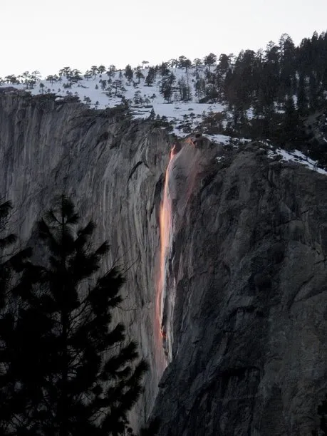
Last year, Yosemite National Park's famed "firefall" was more of a "firedrizzle" due to lack of snow. But this year, the "firefall" is burning bright.
Yosemite's Horsetail Fall flows like lava under a clear sky and favorable lighting. It's a small waterfall that makes big news whenever it glows orange during sunset in mid- to late February. This time of year, the sun is setting at just the right angle and the western sky is just clear enough to create the "firefall" effect. When that happens, the waterfall will glow orange for about 10 minutes.
[Full Story: Wilderness 'Paparazzi' Flock to Yosemite's 'Firefall']
Get the world’s most fascinating discoveries delivered straight to your inbox.
