


Risk of Leslie Hitting Atlantic Canada
This article was provided by AccuWeather.com.
After Hurricane Leslie passes across Bermuda this weekend, the system will move quickly into Atlantic Canada waters early next week.
Residents, travelers and fishing interests from New Brunswick and Nova Scotia to Prince Edward Island, the Gulf of St. Lawrence and Newfoundland should keep a close eye on Leslie and be prepared for tropical storm or hurricane conditions early next week. Conditions could rapidly deteriorate Monday.
Boating and fishing interests in New England should also monitor Leslie and expect significant building seas offshore Sunday into Monday.
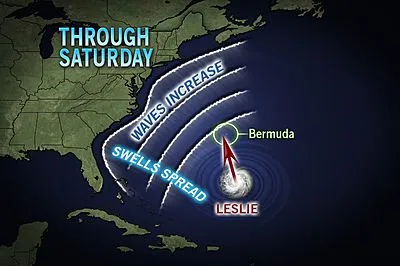
Leslie will generate rough surf and increase the number and strength of rip currents along much of the eastern coast of the United States through the weekend.
Leslie has been moving very slowly about 500 miles south of Bermuda at midweek, but that will soon change.
According to Dan Kottlowski, head of the AccuWeather.com Hurricane Center, "We are confident Leslie will pick up forward speed moving between 20 and 30 mph at the latitude of Nova Scotia and Newfoundland."
Get the world’s most fascinating discoveries delivered straight to your inbox.

Leslie was becoming better organized Wednesday afternoon and is projected to strike Bermuda as a hurricane with Category 1 or 2 strength later Saturday night into Sunday.
The exact path of Leslie is dependent on how a developing trough of low pressure over the eastern United States interacts with the system.
The majority of tropical cyclones are swept to the northeast after passing Bermuda's latitude. However, a small number of systems do not curve enough to avoid a collision with Nova Scotia and/or Newfoundland. In 2003, Juan rolled in from the south across Nova Scotia and caused significant damage.
"There is a possibility that the developing feature over the United States captures Leslie and flings the storm northward or northwestward early next week," Kottlowski said.
Waters are warmer than usual south of Atlantic Canada. The combination of this and quickening steering winds may result in slower weakening of a hurricane either moving by at sea or plowing toward the coast.
Any non-destructive rain would be welcomed over much of Atlantic Canada, due to a warm, dry summer in the region. Unfortunately, in order for significant rain to occur, the system would have to push well inland with damaging wind and flooding rain, rather than brush the coast with a few gusts and brief showers.
© AccuWeather.com. All rights reserved. More from AccuWeather.com.