Mild Earthquake Rattles Northern California Seafloor

Get the world’s most fascinating discoveries delivered straight to your inbox.
You are now subscribed
Your newsletter sign-up was successful
Want to add more newsletters?

Delivered Daily
Daily Newsletter
Sign up for the latest discoveries, groundbreaking research and fascinating breakthroughs that impact you and the wider world direct to your inbox.

Once a week
Life's Little Mysteries
Feed your curiosity with an exclusive mystery every week, solved with science and delivered direct to your inbox before it's seen anywhere else.

Once a week
How It Works
Sign up to our free science & technology newsletter for your weekly fix of fascinating articles, quick quizzes, amazing images, and more

Delivered daily
Space.com Newsletter
Breaking space news, the latest updates on rocket launches, skywatching events and more!

Once a month
Watch This Space
Sign up to our monthly entertainment newsletter to keep up with all our coverage of the latest sci-fi and space movies, tv shows, games and books.

Once a week
Night Sky This Week
Discover this week's must-see night sky events, moon phases, and stunning astrophotos. Sign up for our skywatching newsletter and explore the universe with us!
Join the club
Get full access to premium articles, exclusive features and a growing list of member rewards.
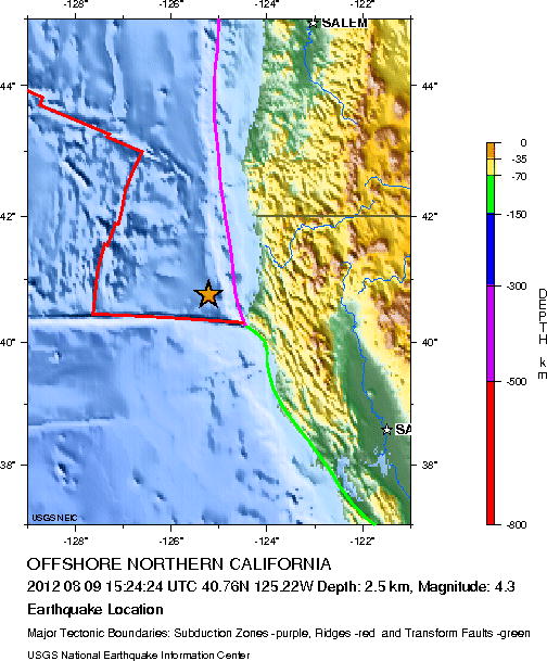
A minor earthquake rumbled offshore in Northern California today. The preliminary magnitude was 4.3, according to the U.S. Geological Survey. It's likely that residents didn't feel any shaking, according to USGS maps. Details from the USGS:
Date-Time:
Thursday, August 09, 2012 at 15:24:24 UTC
Thursday, August 09, 2012 at 08:24:24 AM at epicenter
Location: 40.757°N, 125.217°W
Depth: 2.5 km (1.6 miles) (poorly constrained)
Distances from epicenter:
Get the world’s most fascinating discoveries delivered straight to your inbox.
83 km (52 miles) WNW (284°) from Ferndale, CA
85 km (53 miles) W (272°) from Humboldt Hill, CA
87 km (54 miles) W (270°) from Bayview, CA
89 km (55 miles) W (268°) from Eureka, CA
This page will be updated if the event proves significant.
 Live Science Plus


