


Fall 2012: Snow for Rockies; Warmth Grips Midwest, Northeast
This article was provided by AccuWeather.com.
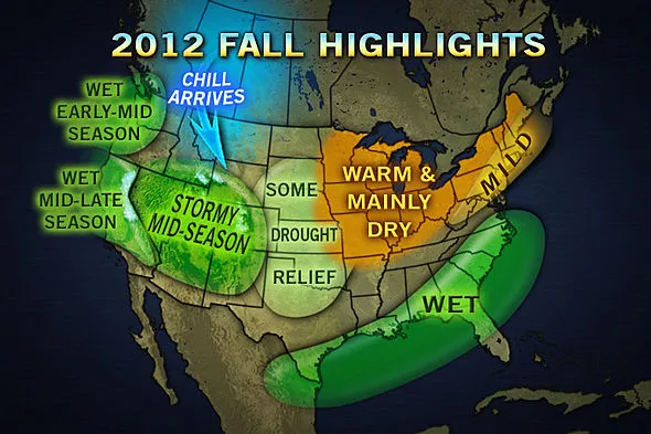
The return of chilly air and early season snow is expected in the Rockies for Fall 2012, while temperatures will remain mild for portions of the Midwest and Northeast.
The Southeast and Gulf Coast will be soggy, and some drought relief is in store for the the Plains.

A breakdown of the Fall 2012 forecast can be found below.
Jump to: Chill to Return to Rockies First | Four Corners a Hot Spot for Snow By Mid-Season | Some Rain Relief for the Plains | Wet for Southeast, Gulf Coast | Warm, Dry Fall for Ohio Valley, Great Lakes, Parts of the Northeast | Wet Early-Mid Season in Northwest, Then Shifting to California
Chill to Return to Rockies First While cold air may be delayed in arriving across areas farther east in the nation, cold shots will not have a problem reaching the Rockies. This is the first area that may be at risk for early frosts and freezes.
"I think there will be some early cold outbreaks out over the central and northern Rockies, especially. I think that where the season-winter season-actually is going to start much quicker," Pastelok emphasized.
Get the world’s most fascinating discoveries delivered straight to your inbox.
Temperatures are expected to average 1-2 degrees below normal for the northern Rockies this fall.
Four Corners a Hot Spot for Snow By Mid-Season The central and southern Rockies, spanning the Four Corners region, may be a hot spot for snow by the middle of the season.
The mountains in Utah, Arizona, Colorado and New Mexico may start to get snowfall during October.
Colorado ski lift photo posted by Flickr user dkwonsh.
"As far as early snowfall goes, I think places in the Four Corner region will be the places to watch. The jet stream will be increasing across that area. And I think they will start to see some snow falling by as early as early- to mid-October," Pastelok said.
A possible early kick start to the ski season in the Rockies is great news for both ski enthusiasts and the ski industry.
Some Rain Relief for the Plains Before monsoon moisture tapers off across the Southwest and as storms begin to impact the Northwest in the fall, some moisture will stream into portions of the central and southern Plains at times.
The rain will be beneficial for communities that have been suffering severe to exceptional drought conditions.

Western and central portions of Nebraska, Kansas, Colorado, Oklahoma and Texas will get some rain relief from the brutal drought. Conditions have been very bad for brush and grass fires, and the return of rain should help the situation.
Wet for Southeast, Gulf Coast Communities across eastern Texas, the Gulf Coast and Southeast will have a wet fall due to a combination of potential tropical system landfalls and fronts that stall across the region.
Two more direct landfalls from tropical systems are forecast in the U.S. as the hurricane season picks up during August and September, according to AccuWeather Expert Senior Meteorologist Dan Kottlowski. The central Gulf Coast to the Southeast coast, from southern Mississippi eastward to Florida and then northward to southern Virginia, is the most likely to get hit.
RELATED: The Worst is Yet to Come with the Atlantic Hurricane Season Atlantic Hurricane Season: Record Start, Followed by a Lull
A gradual fading of the tropical season is expected to occur during October, depending on how fast and strong El Niño comes on. El Niño is a phenomenon characterized by above-normal water temperatures across the central and equatorial Pacific.
However, while tropical season winds down, soggy weather should continue to hammer the region from other sources.
"We have to be careful along the Gulf Coast, particularly from Louisiana into the Southeast. There is the potential for fronts stalling out and causing widespread flooding. That's an area of concern as we get into October and November especially," AccuWeather Lead Long-Range Forecaster Paul Pastelok said.
New Orleans, La., Montgomery, Ala., Atlanta, Ga., Columbia, S.C., and Raleigh, N.C., are among the cities that will be wet this fall.
Some of the moisture will stream into the southern mid-Atlantic at times as well, for cities such as Norfolk and Richmond, Va.
Warm, Dry Fall for Ohio Valley, Great Lakes, Parts of the Northeast The center of hot and dry weather has kept a tight grip of the central Plains and Midwest over the summer. The warm and dry weather for the fall will shift farther east across the Great Lakes, Ohio Valley and interior Northeast.
Unfortunately, drought-stricken areas of the Ohio Valley will continue to deal with above-normal warmth and below-normal precipitation.
The Northeast, which got hit by a nasty Halloween snowstorm last year, will have a slower return of chilly air. Early season snow is not likely for the I-95 cities, because it may take a while for cold air to sink up with huge storms.
However, the frost forecast is much more difficult.
"The early frost prediction is a very difficult one, because you can still get frost in areas that are above-normal for the fall season. For instance, like the Midwest and central Plains states, they can still see a normal to maybe early frost. I think it is more likely in the central and northern Rockies and least likely in the Northeast," explained Pastelok.
Wet Early-Mid Season in Northwest, Then Shifting to California It will start out wet during the early and middle of the fall in the Northwest.
"I think it will start out wetter, but get drier in the late fall season, which could set up for a fairly dry or at least below-normal winter season across areas like Seattle and Spokane," Pastelok added.
Wet weather will shift farther south across much of California during the middle to latter part of the season. A wet late-fall is in store for San Francisco.
Increased snowfall expected in the Sierra is good news for California water supply, following a significant snow drought last winter.
© AccuWeather.com. All rights reserved. More from AccuWeather.com.