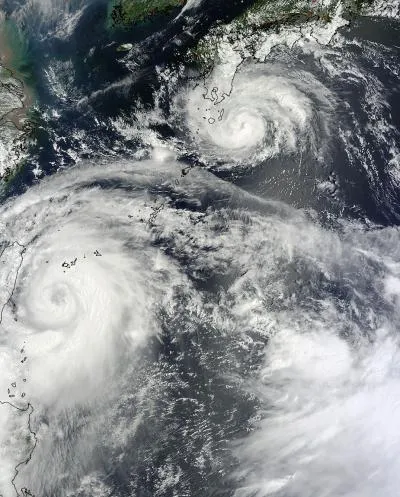
NASA's Terra satellite caught Typhoon Saola and Typhoon Damrey in the same view on Aug. 1 as the former approached Taiwan and the later Japan. Both were on their way to a landfall in China.
Saola is forecast to landfall south of Shanghai on Aug. 3, while Damrey is forecast to make landfall north of Shanghai today (Aug. 2).
NASA's satellites have been tracking the twin typhoons along with the Joint Typhoon Warning Center. In the Aug. 1 image, Saola is much bigger than Damrey and possesses an eye, a sign of a strong, well-organized storm.
Latest Videos From
As of the latest JTWC update, Damrey had maximum sustained winds of about 75 mph (120 kph), which would just barely give it hurricane status in the Atlantic basin. (Hurricanes and typhoons are the same phenomenon.) Damrey was about 365 nautical miles (675 kilometers) south-southeast of Beijing at that update and moving toward the northwest. The storm's projected path has it making landfall between Beijing and Shanghai.
Saola has maximum winds of 52 mph (83 kph) and is situated about 40 nautical miles (74 km) north-northwest of Taipai, Taiwan.
Damrey is expected to weaken, especially after it makes landfall and is disrupted by the rugged terrain. Saola could intensify as it move over the Taiwan Strait before it makes landfall near Fuzhou, China.

 Live Science Plus