
 Live Science Plus


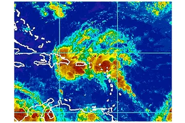
Tropical System Drenching the Caribbean
This article was provided by AccuWeather.com.
A strong tropical wave was bringing the most significant and widespread rain in months to some of the northern Caribbean islands this week.
The rainfall will be very beneficial for residents for drinking water and agricultural considerations. However, there is also the negative impact to tourists in the area to consider and the slight chance, at a very isolated level, the rainfall could be intense enough to cause flash and urban flooding.

The feature was spreading drenching showers and locally gusty thunderstorms over the Leeward islands during the first part of the week.
As of the Tuesday morning, the system was bringing locally heavy rain to much of Puerto Rico, part of the Dominican Republic and the Leeward Islands.
The system will continue to move along a general, slightly curved west to northwest track over the next five days or so.

Additional downpours and isolated squalls will affect the Leeward Islands through Tuesday. The United States and British Virgin islands, along with Puerto Rico can expect the needy, yet disruptive downpours to be around into Wednesday.
Get the world’s most fascinating discoveries delivered straight to your inbox.
The showers and thunderstorms will roll across Hispaniola, primarily Tuesday into Thursday and then over portions of Cuba and the Bahamas Wednesday into Friday.
Over the approximate three-day period in which the storm will affect most locations, there will be an average of 2 to 4 inches of rain on the Greater Antilles and 1 to perhaps 2 inches on the smaller islands in the northern Caribbean.
The pulse of moisture associated with the system is forecast to reach Florida this weekend.
Although a strong feature last week right out of the box from Africa, through this past weekend it has not shown enough organization thus far to classify it as a tropical depression or storm.
There have been gusts to 32 mph in squalls in Le Raizet early Monday morning. Gusts were in the neighborhood of 30 mph in St. Thomas, U.S. Virgin Islands.
Sabana de La Mar, Dominican Republic has received 1.50 inches of rain during the 24-hour period ending at 8:00 a.m. EDT, Tuesday, July 31, 2012. Rainfall between 0.50 and 1.00 inch has been common during the same 24-hour period in the Leeward Islands with 0.10 to 0.24 of and inch in the Windward Islands.
While modest development with the system is possible this week, rapid intensification does not appear to be likely for the next several days.
According to Tropical Weather Expert Dan Kottlowski, "We are monitoring surface pressure in the region. Thus, far barometric pressure is rather high around the system."
A drop in surface pressure would indicate development.
"If the system curves more to the north late this week and beyond, there is a little better chance for organization/development," Kottlowski said.
As long as the feature does not substantially organize, the zone of showers and thunderstorms will tend to be spread out over a broad area.
Another feature over the south-central Atlantic is also being watched.
"The central Atlantic system already has a large, established circulation and has a very good chance of developing this week," Kottlowski said.
© AccuWeather.com. All rights reserved. More from AccuWeather.com.