It's quick and easy to access Live Science Plus, simply enter your email below. We'll send you a confirmation and sign you up for our daily newsletter, keeping you up to date with the latest science news.
Guchol, a tropical cyclone in the western Pacific, has its sights set on Japan. Winds currently are 120 mph, with even higher gusts. If Guchol were an Atlantic hurricane, it would be considered a Category 3 storm.
Guchol is currently bringing strong winds and squally rains to the southern Ryukyu Islands, and conditions will continue to deteriorate over the next 12 hours as the storm passes over the island chain.
Conditions for Guchol have been favorable over the past 24 hours, with low wind shear and warm ocean waters feeding the storm. As Guchol moves farther north, it will encounter both more shear and cooler water temperatures leading to a slow weakening of the system over the next 24 hours as it approaches southern Japan.
(Image credit: Courtesy of Accuweather.com)
Satellite imagery of Guchol as of late Saturday local time. Image from Joint Typhoon Warning Center
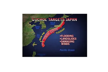
Guchol is expected to make a landfall near Shikoku and southern Honshu Tuesday afternoon. The strongest winds usually occur on the right side of the storm track, meaning the most damaging winds are expected across southeastern Honshu.
Guchol is expected to track northeastward taking the storm across much of Japan before finally weakening into a extra tropical low pressure later Wednesday or Thursday. The main threat the storm poses to the remainder of Japan will be its torrential rain. Heavy rain could lead to mudslides and flash flooding, especially in the mountains just west of Tokyo.
Sign up for the Live Science daily newsletter now
Get the world’s most fascinating discoveries delivered straight to your inbox.
Flooding rainfall will also be possible north of Tokyo in areas devastated by the earthquake and tsunami in 2011. The threat of damaging winds will be greatly reduced by the time the storm reaches these areas.
To make matters worse for Japan, Tropical Storm Talim formed off the coast of southeast China on Sunday. Computer models suggest this storm will track to the northeast, passing near Taiwan on Wednesday then approaching Japan by Friday. This system could bring another round of flooding rainfall to areas that will be trying to recover from Guchol.
Meteorologist Eric Leister contributed to this story.