














Tropical Storm Irina Looping the Loop Before African Landfall

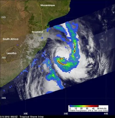
Tropical Storm as it has been "going loopy" in the Mozambique Channel over the last couple of days as it has been monitored by NASA satellites.
Irina is making a cyclonic loop, something that a tropical cyclone does on occasion whenever there are a couple of weather systems that push it in different directions, according to a NASA statement.
Irina is currently parallel to the middle of South Africa, about 315 nautical miles south-southeast of Maputo, Mozambique, and moving toward the southeast. But the storm is expected to start curving toward the northeast and then the northwest as it continues making a loop that will take it back toward a landfall in extreme northeastern South Africa on March 9.
Weather systems in the area are pushing past Irina, acting as guides for the storm to follow and causing it to loop around. The last weather system that will turn it back to the north is a ridge or elongated area) of high pressure that's strengthening over South Africa and will turn Irina to the northwest.
Infrared data from Atmospheric Infrared Sounder (AIRS) instrument on NASA's Aqua satellite showed on March 5, that most of the strongest thunderstorms and heaviest rainfall are occurring in the southern half of the storm. The strongest thunderstorms usually have the highest, and coldest cloud top temperatures, which is what AIRS infrared data reads.
NASA's Tropical Rainfall Measuring Mission (TRMM) satellite passed over Irina on March 5, 2012 at 0023 UTC (2:23 a.m. local time in South Africa and 7:23 p.m. on March 4) EST. A rainfall analysis from TRMM's Microwave Imager (TMI) and Precipitation Radar (PR) instruments showed areas of heavy rainfall in several areas, mostly south of the center of circulation.
There are several parks located near where landfall is currently forecast. Tembe Elephant Park and the Ndumo Game Reserve are located near the Mozambique border and the Isimangaliso Wetland Park is located to the south. These areas are likely to feel the strongest winds from Irina when it makes landfall.
Get the world’s most fascinating discoveries delivered straight to your inbox.
As Irina nears landfall by the end of the week, cold waters stirred up from below the surface are causing sea surface temperatures near the coast to cool, which will reduce any energy going into Irina as it nears the coast for landfall. Once Irina makes landfall, the forecasters at the Joint Typhoon Warning center expect Irina to dissipate quickly. Meanwhile residents of eastern South Africa, Swaziland and southeastern Mozambique can expect more clouds, showers, gusty winds and rough surf in coastal areas as Irina loops back toward land.
