


Scientists Fly Antarctic Skies to See Ice in Action
For the third year running, scientists have taken to the skies to map and monitor changes in Antarctic ice, and today (Nov. 3) researchers discussed this year's expedition to the southern continent during a teleconference from their operations base in Punta Arenas, Chile.
Scientists and crew with NASA's Operation IceBridge said that so far, this year's mission has been a success. In addition to gathering invaluable data on the four primary types of Antarctic ice ice sheets, glaciers, ice shelves and sea ice the mission made an exciting discovery: the birth pangs of a large iceberg .
Scientists first glimpsed an ever-widening crack on a massive plain of floating ice on Oct. 14. The rift is deeper than the Statue of Liberty is tall, and stretches about 18 miles (29 kilometers) across the ice plain. It is widening by more than 6 feet (2 meters) per day.
An iceberg more than 10 times the area of Manhattan will likely break off and float away toward the end of this year or in early 2012. Scientists emphasized that the event is not unusual, nor is the iceberg unusually large.
The IceBridge mission kicked off in 2009 to fill an observational void created when an ice-measuring satellite powered down, while its successor, ICESat-2, is prepared for launch in 2016. [See images from the IceBridge Antarctic campaign here .]
Project scientist Michael Studinger said that a large gap in data would have been disastrous for researchers studying changes in polar ice.
"Our study plan is based on a desire to avoid an 'Oh my god' moment in 2016 when ICESat-2 starts collecting data," Studinger told reporters. "So we need to monitor the change in the thickness of the ice from 2009 to 2016."
Get the world’s most fascinating discoveries delivered straight to your inbox.
Overall, Studinger said, long-term study of Antarctic ice is motivated in large part by scientists' concern about sea level rise due to global warming. "Antarctica contributes about one-third to this sea level rise," he said.

Frigid flights
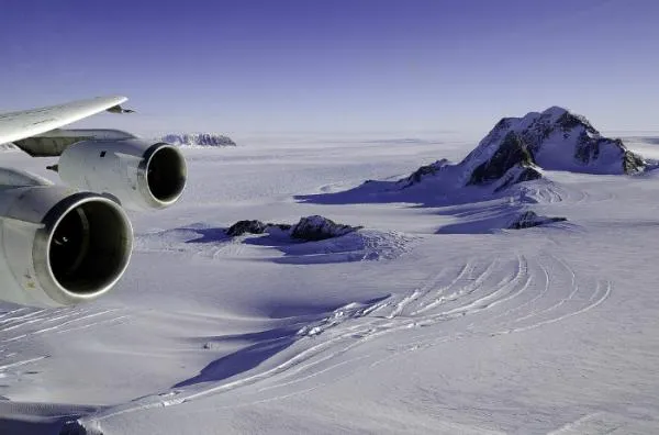
Using a suite of instruments packed aboard two aircraft a massive DC-8 and a sleeker Gulfstream-V (G-V) the mission takes detailed measurements on ice thickness and elevation, and maps bedrock below.
The flights can be grueling. Each mission typically lasts between 11 and 12 hours, and the planes are flooded with blinding light reflecting off the icy landscapes below, lit by the near-perpetual daylight of Antarctic summer.
Pilots must follow exacting flight paths to be sure data are collected from the same spot from year to year.
During data runs the DC-8 typically flies at just 1,500 feet (460 m), in weather that is notoriously mercurial and often rough.
"Over some of these glaciers you're flying in and out of canyons that are three or four thousand feet deep," said NASA pilot Troy Asher.
So far this year, the two aircraft have flown 24 missions, covering more than 100,000 miles (161,000 km). Although the G-V has completed its Antarctic run, the DC-8 is out flying today, and is slated to return to the United States in mid-November.

Data, data everywhere
Studinger said it's too early to make any grand pronouncements about the data the mission has gathered this year, but he did say witnessing the birth of an iceberg was interesting.
The berg is breaking off, or "calving," not from the glacier itself, but from its ice shelf, which is essentially a colossal floating plate of ice the outlet of a glacier that is cemented to the edge of the continent. The calving ice shelf is attached to the Pine Island Glacier, one of the largest and fastest moving glaciers in Antarctica.
"What makes it exciting is that we happened to be here and see it happening, but it's not the major story of Pine Island Glacier," Studinger said.
In fact, scientists had been expecting the ice shelf to produce a large iceberg sometime soon. The ice shelf last produced a large iceberg in 2001 and then again in 2007, and these calving events appear to happen on a roughly decade-long cycle.
Although the nascent iceberg is quite large about 300 square miles (880 square km) scientists said its breadth isn't anything out of the ordinary.
"A good-sized berg has to be kept in context with the scale of the glacier producing it. Pine Island is quite big and has a history of producing such bergs," said Christopher Shuman, a research scientist who has been flying on the DC-8 this season.
Pine Island Glacier is particularly interesting to scientists not only because of its massive size, but because the monstrous river of ice has been picking up speed.
"The glacier has been speeding up incredibly 20 years ago it was not the fastest glacier in Antarctica," said Ken Mankoff, a glaciology and oceanography Ph.D. student at the University of California Santa Cruz who studies the Pine Island Glacier, and the human behind the glacier's Twitter feed. ("I cracked!" @AntarcticPIG recently tweeted.)
"Every year, we see that the area where the glacier is thinning is growing," Studinger said. The thinning is extending farther and farther inland, he said so much so that last year the IceBridge team had to alter flight paths to be able to see the extent of the thinning.
Large, antsy glaciers on a distant continent, and the changes in their attached ice shelves are more than esoteric study subjects for researchers. Ice dynamics in faraway places can have repercussions around the world, the scientists said.
Evidence suggests that thinning ice shelves lead to faster flow of major deep glaciers, which leads to increased mass movement into the global ocean, Shuman told OurAmazingPlanet.
The IceBridge mission will wrap up Antarctic operations in several weeks. The mission leapfrogs back and forth between polar regions, flying Arctic ice during warmer months in the Northern Hemisphere.
- See Video of the Flight Over the Glacier Crack
- Images: NASA's IceBridge in Action Over Antarctica
- Gallery: An Expedition into Iceberg Alley
You can follow OurAmazingPlanet staff writer Andrea Mustain on Twitter:@andreamustain. Follow OurAmazingPlanet for the latest in Earth science and exploration news on Twitter @OAPlanet and on Facebook