It's quick and easy to access Live Science Plus, simply enter your email below. We'll send you a confirmation and sign you up for our daily newsletter, keeping you up to date with the latest science news.
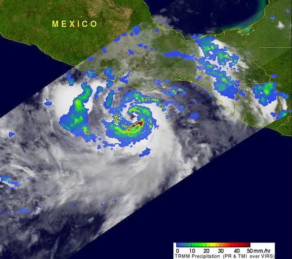
The TRMM satellite passed over Hurricane Hilary on September 22 at 0147 UTC. Hilary contained several areas of heavy rain falling at 2 inches (50 mm) per hour (red) on northern, western and southern sides of the storm's center. Yellow and green areas indicate moderate rainfall between .78 to 1.57 inches (20 to 40 mm) per hour.
Hilary strengthened rapidly yesterday afternoon in the warm waters of the eastern Pacific. Today, Sept. 23, Hilary has become a major hurricane. The Tropical Rainfall Measuring Mission (TRMM) satellite flew over Hilary yesterday after it reached hurricane status and saw hot towers around the storm's center which clued forecasters that Hilary would intensify - and she did, into a major hurricane.
A major hurricane is a storm Category 3 or higher on the Saffir-Simpson scale that rates hurricane intensity. Hilary is a Category Four Hurricane. A Category Four Hurricane has sustained winds between 131 and 155 mph, (114-135 knots, or 210-249 kmh) and the scale indicates with storms in that category "catastrophic damage will occur."
The TRMM satellite passed over Hurricane Hilary on September 22 at 0147 UTC. TRMM Precipitation Radar (PR) data showed that Hilary contained several areas of heavy rainfall (about 2 inches/50 mm) per hour in the northern, western and southern sides of the storm's center. Hilary also had "hot towers" around her center of circulation which clued forecasters that she would be intensifying. A "hot tower" is a rain cloud that reaches at least to the top of the troposphere, the lowest layer of the atmosphere. It extends approximately nine miles (14.5 km) high in the tropics. These towers are called "hot" because they rise to such altitude due to their large amount of latent heat. Water vapor releases this latent heat as it condenses into liquid. NASA research shows a tropical cyclone with a hot tower in its eyewall was twice as likely to intensify within the next six hours than a cyclone that lacked a tower. Hilary continued to intensify overnight.
The GOES-11 satellite captured this infrared image of major hurricane Hilary on Friday, Sept. 22 at 2 a.m. EDT. Notice that Hilary's eye is clearly visible.
(Image credit: NASA/NOAA GOES Project)
In infrared imagery of major Hurricane Hilary from NOAA's GOES-11 satellite on Friday, Sept. 22 at 2 a.m. EDT, the 10 nautical-mile in diameter eye is clearly visible. The NASA GOES Project at NASA's Goddard Space Flight Center, Greenbelt, Md. created the image. Infrared data shows that there is a thick area of very high, cold cloud tops surrounding Hilary's eye. That means high and powerful thunderstorms continue to generate the latent heat powering the storm.
The environment Hilary is located in is helping maintain her strength. Hilary is located over very warm waters, much warmer than the 80F (26.6C) threshold needed to power storms. There's also very light wind shear. Wind shear means winds outside the storm that can buffet it, displace the rainfall from its center and tear the storm apart.
Thankfully, Hilary is moving away from southwestern Mexico but heavy rain, dangerous surf and tropical storm force winds are still being experienced today. Hilary is expected to produce rainfall amounts of 3 to 5 inches across southern Guerrero and southern Michoacan in southern Mexico with isolated amounts of 10 inches possible.
At 8 a.m. EDT on Sept. 23, Hurricane Hilary had maximum sustained winds near 145 mph. It was located about 125 miles (200 km) south-southwest of Zihuatanejo, Mexico near 15.9 North and 102.1 West. It was moving away from the coast in a westerly direction at 10 mph (16 kmh). Minimum central pressure was 944 millibars.
Sign up for the Live Science daily newsletter now
Get the world’s most fascinating discoveries delivered straight to your inbox.
A tropical storm warning is in effect for west of Acapulco Mexico westward to Punta San Telmo and a tropical storm watch is in effect for west of Punta San Telmo to Manzanillo. The National Hurricane Center noted that the tropical storm watch and warning could be discontinued during the morning of Sept. 23.
Hilary is expected to maintain major hurricane status over the weekend as it moves in a westerly direction and further away from land.
For the science geek in everyone, Live Science offers a fascinating window into the natural and technological world, delivering comprehensive and compelling news and analysis on everything from dinosaur discoveries, archaeological finds and amazing animals to health, innovation and wearable technology. We aim to empower and inspire our readers with the tools needed to understand the world and appreciate its everyday awe.