Typhoon Roke promises to bring unwelcome rain to areas of Japan still recovering from Typhoon Talas , which triggered landslides and floods across the Kii Peninsula in early September.
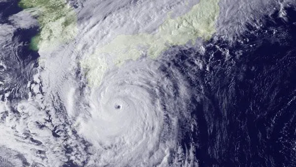
Roke is about 180 miles south of the Japanese mainland and is expected to make landfall to the west of Tokyo tomorrow (Sept. 21).
The swirling storm currently has maximum sustained winds of about 132 mph (213 kph), putting it just over the threshold of a Category 4 storm on the Saffir-Simpson scale used for Atlantic basin hurricanes. The storm is large and well-formed with a distinct eye. [Related: How Do Typhoons and Hurricanes Differ?]
Latest Videos From
The new typhoon may trigger additional landslides and floods, particularly as rainwater builds up behind and bursts through mud dams formed by landslides during Typhoon Talas.
Fearing floods from two rivers, officials in the city of Nagoya ordered the evacuation of 80,000 people and advised more than a million more to evacuate, said The Japan Times. Roke could bring as much as 20 inches (50 cm) of rain to parts of Japan.