It's quick and easy to access Live Science Plus, simply enter your email below. We'll send you a confirmation and sign you up for our daily newsletter, keeping you up to date with the latest science news.
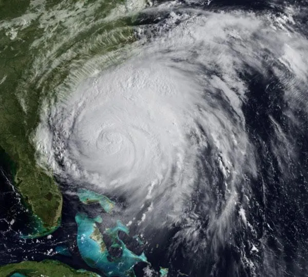
The huge mass of Hurricane Irene was spied bearing down on the U.S. East Coast by satellites early today (Aug. 26).
Irene finally left the Bahamas to recover from it's wrath and began its push toward the Eastern Seaboard overnight. Parts of coastal South Carolina and North Carolina are already beginning to feel the effects of the storm, with power even out in one South Carolina coastal town, according to news reports. [See video of Irene's path here.]
The storm has weakened slightly to a Category 2 hurricane with winds of 105 mph (165 kph), but it could still pack a dangerous punch to the communities along the U.S. East Coast from North Carolina to New England. Irene is a large hurricane with hurricane-force winds extending out to 90 miles (150 kilometers) from the storm's center.
A hurricane warning is in place from Little River Inlet in North Carolina to Sandy Hook, N.J., which is just south of New York City. A hurricane watch is in effect north of Sandy Hook to the mouth of the Merrimack River in Massachusetts. Warnings are issues 36 hours before hurricane conditions are expected in an area and watches 48 hours in advance. [What Hurricane Irene Holds in Store for NYC ]
Storm surge is expected to be between 6 and 11 feet (1.8 to 3.4 meters) in North Carolina, 4 and 8 feet (1.2 to 2.4 m) in Chesapeake Bay and the Delmarva Peninsula, and 3 and 6 feet (0.9 to 1.8 m) along the Jersey Shore.
Hurricane Irene's projected path as of the morning of Aug. 26.
(Image credit: NHC/NOAA)
Irene is the first hurricane and first major hurricane for what has been forecast to be an active season. The National Oceanic and Atmospheric Administration (NOAA) updated its forecast on Aug. 4, predicting 14 to 19 named storms (which include tropical storms and hurricanes), seven to 10 hurricanes and three to five major hurricanes. An average Atlantic hurricane season will see 11 named storms, six hurricanes and two major hurricanes. August through October are the peak months of the Atlantic hurricane season.
Sign up for the Live Science daily newsletter now
Get the world’s most fascinating discoveries delivered straight to your inbox.
For the science geek in everyone, Live Science offers a fascinating window into the natural and technological world, delivering comprehensive and compelling news and analysis on everything from dinosaur discoveries, archaeological finds and amazing animals to health, innovation and wearable technology. We aim to empower and inspire our readers with the tools needed to understand the world and appreciate its everyday awe.

 Live Science Plus