Satellite Follows Georgia Tornado Path
Get the world’s most fascinating discoveries delivered straight to your inbox.
You are now subscribed
Your newsletter sign-up was successful
Want to add more newsletters?
Delivered Daily
Daily Newsletter
Sign up for the latest discoveries, groundbreaking research and fascinating breakthroughs that impact you and the wider world direct to your inbox.
Once a week
Life's Little Mysteries
Feed your curiosity with an exclusive mystery every week, solved with science and delivered direct to your inbox before it's seen anywhere else.
Once a week
How It Works
Sign up to our free science & technology newsletter for your weekly fix of fascinating articles, quick quizzes, amazing images, and more
Delivered daily
Space.com Newsletter
Breaking space news, the latest updates on rocket launches, skywatching events and more!
Once a month
Watch This Space
Sign up to our monthly entertainment newsletter to keep up with all our coverage of the latest sci-fi and space movies, tv shows, games and books.
Once a week
Night Sky This Week
Discover this week's must-see night sky events, moon phases, and stunning astrophotos. Sign up for our skywatching newsletter and explore the universe with us!
Join the club
Get full access to premium articles, exclusive features and a growing list of member rewards.
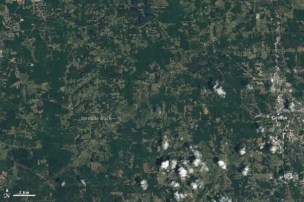
A pale green swath in this Landsat image from April 28, 2011, reveals the path of a tornado outside of Griffin, Georgia, according to a NASA statement.
The tornado was on the ground between 12:03 and 12:28 a.m. local time on April 28, hours before the image was taken. By the time the funnel cloud lifted, the tornado had covered about 20 miles with a path about half a mile wide, said the National Weather Service.
The tornado was an EF3 tornado with winds of about 140 miles per hour.
This image shows that the tornado moved across lightly populated farmland. Bright-colored spots are buildings, and some are close to storm's path. The town of Griffin, shown on the far right, is the nearest community to the storm track in this area.
- Tracks of Alabama Tornadoes Spied from Space
- Why Were the Southern Tornadoes So Deadly?
- In Images: Tornado Damage Scale
Get the world’s most fascinating discoveries delivered straight to your inbox.

