Tropical Storm Tasha Lashes Australia
Get the world’s most fascinating discoveries delivered straight to your inbox.
You are now subscribed
Your newsletter sign-up was successful
Want to add more newsletters?
Delivered Daily
Daily Newsletter
Sign up for the latest discoveries, groundbreaking research and fascinating breakthroughs that impact you and the wider world direct to your inbox.
Once a week
Life's Little Mysteries
Feed your curiosity with an exclusive mystery every week, solved with science and delivered direct to your inbox before it's seen anywhere else.
Once a week
How It Works
Sign up to our free science & technology newsletter for your weekly fix of fascinating articles, quick quizzes, amazing images, and more
Delivered daily
Space.com Newsletter
Breaking space news, the latest updates on rocket launches, skywatching events and more!
Once a month
Watch This Space
Sign up to our monthly entertainment newsletter to keep up with all our coverage of the latest sci-fi and space movies, tv shows, games and books.
Once a week
Night Sky This Week
Discover this week's must-see night sky events, moon phases, and stunning astrophotos. Sign up for our skywatching newsletter and explore the universe with us!
Join the club
Get full access to premium articles, exclusive features and a growing list of member rewards.
While the U.S. Northeast was getting socked by snow , the coast of Queensland, Australia, got a wet lashing from Tropical Storm Tasha for Christmas.
On Dec. 24, Tropical Storm Tasha formed quickly and headed for landfall near Cairns, Australia.
That same day, at 3:14 p.m. EST (6:14 a.m. local time on Dec. 25), the Australia Bureau of Meteorology issued a Severe Weather Warning, calling for "damaging winds, heavy rainfall and further flooding for people about the Queensland coast, ranges and adjacent inland areas between Cardwell and St Lawrence." In addition, a High Surf Warning was posted.
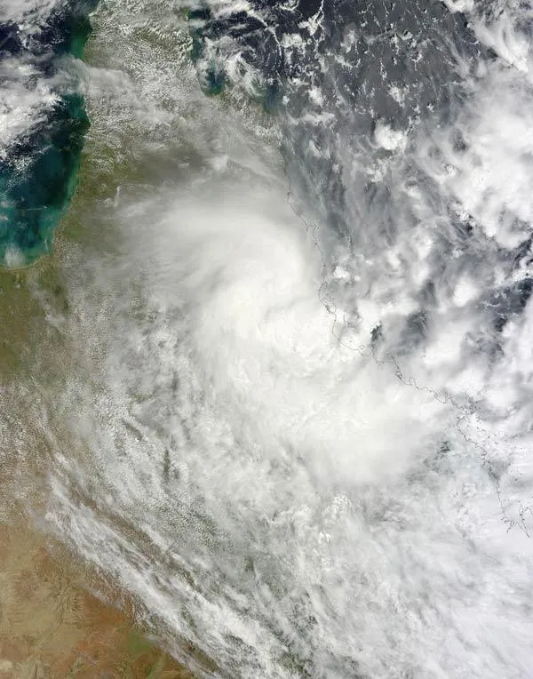
On Christmas Day, at 2 p.m. local time, NASA's Terra Satellite captured a visible image of Tropical Cyclone Tasha inland over northeastern Australia. The satellite image showed an area of very bright white clouds around the center of the storm indicating the highest, strongest thunderstorms within the tropical storm.
Tasha was generating rainfall at up to 2 inches (50 mm) per hour before it made landfall, according to NASA's TRMM satellite data. That heavy rainfall combined with another weather system that affected Queensland and created record flooding as Tasha made landfall and moved inland.
Get the world’s most fascinating discoveries delivered straight to your inbox.

